You will also be interested
[EN VIDÉO] Threatened by erosion, the coastline is monitored by satellite The coast is perpetually subject to the ocean, so that storms, rising sea levels and erosion are a permanent threat to it. The Cnes explains to us in a video how satellites allow effective monitoring and safeguarding of these sites.
If it is obvious that the mountains are born under the effect of compressive tectonic forces, their life of mature relief is governed by a balance between plate convergence rateisostatic equilibrium and erosive processes.
Like every square centimeter of the earth’s surface, mountains are indeed subject toabrasion and the continued weathering of wind and water. They are all the more so as the relief is important. These surface processes also play a major role in climate regulation, with certain weathering reactions being associated with CO fixation.2 atmospheric. The weathering of rocks also makes available large amounts of nutrients that will enrich the oceans and sustain marine productivity. It is commonly accepted that the uplift of large mountain ranges is accompanied by an increase in rock weathering processes, which can have a significant impact on the climate system. Climate and tectonics are thus intimately linked.
How do mountains manage to maintain their height despite erosion?
However, it is not yet clear how these different forces that control the height of mountains are balanced (or not) in the very long term. It appears that despite very high rates of erosion, some orogens assets still manage to “survive” and maintain their topography for hundreds of millions of years.
A research team therefore set out to design a new digital model coupling surface processes, tectonic forces and resistance lithospheric. For this, they used a new parameter, called “Beaumont number” (Bm) in reference to researcher Christopher Beaumont (Dalhousie University, Halifax, Canada) who developed it. This dimensionless number makes it easier to quantify the different factors controlling the topographic evolution of the reliefs and to identify the one that is then dominant.
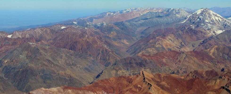
Three types of mountains
Three types of active orogens have thus been defined. Type 1 (Bm>0.5) corresponds to an unstable state, controlled mainly by tectonic forces and the dynamics of the lithosphere. Mountains therefore continue to grow, despite the action of surface processes. This is the case for example of the two most important mountain ranges : the Himalayas and the Andes. Type 2 (Bm approximately equal to 0.4-0.5) corresponds to a stable state dominated by tectonic forces. The height of the reliefs remains constant here, the strong topographic growth linked to plate tectonics and the dynamics of the lithosphere being effectively counterbalanced by surface processes. This is the case of Taiwan. Type 3 (Bm<0.4) corresponds to a stable state dominated this time by erosion. The height is also constant over time, but here it is erosion that is counterbalanced by tectonics. An example: the Southern Alps in New Zealand (be careful, despite the name, it is in no way the Alps that mark the topography of Western Europe).
Climate, Crustal Strength, and Plate Convergence Rate
The new numerical model developed by the team thus makes it possible to quantify the effect of the various factors affecting the height of mountains. The main parameters that come into play are the climate of the region, which directly determines the rate of erosion and weathering, but also the resistance of the lithospherewhich will govern the rebound capacity of the crust in response to abrasion, as well as the speed plate convergence.
In a simplified way, the results published in the journal Nature show that to understand the topographic dynamics of a mountain range, it is enough to know if the climate is wet or dry, if the crust is strong or weak, and if the plates converge quickly or slowly.
Is the height of mountain ranges influenced by erosion or plate tectonics?
The origin of the elevation of mountain ranges has long been a subject of debate among scientists. Is this rather influenced by erosion caused by the elements, or could plate tectonics have a role to play? A new study offers an answer.
Article of Emma Hollen published on June 11, 2020
This is a debate that has animated the scientific community for a long time: does erosion determine the height of the summits of mountain ranges or is their altitude rather influenced by tectonic processes? A new study published in the journal Nature provides new answers, suggesting that plate subduction at the origin of the rise of these rock giants, would also come to counterbalance the erosive action of the elements.
At the origin of mountain ranges
The highest mountain ranges in Earth stand on the border between tectonic plates convergent. The Himalayan range, for example, is the result of the collision between the Indian and Eurasian plates, while the Andes Cordillera emerged from the meeting of the South American, Nazca and Antarctic. The compression exerted by the latter two against the South American plate over the last 20 million years has allowed the elevation of the region to an altitude in places exceeding 1,500 meters.
During this process, called subduction “, two plates move towards each other until the oceanic plate is forced to slip under the continental plate in order to continue its journey, sinking into the depths of the terrestrial mantle. This geological embrace causes a strong seismic activity and volcanic; over millions of years, it causes the progressive and titanic deformation of the upper plate, forming alternately a mountain range, or a basin like the Aegean Sea.
A balance between erosion and subduction
In their new study, researcher Armin Dielforder and his team explain that erosion by rivers and glaciers mountain peaks is not enough to drastically reduce the elevation of mountain ranges. By analyzing the properties of tectonic plates forming massifs and by calculating the forces applied at the junction between them, the researchers were able to demonstrate a correlation between the forces at the edge of the plates on one side, and the altitude and the weight of the mountains on the other .
This correlation was observed for all the massifs studied, located at various latitudes and therefore subject to different climates and erosion rates. In conclusion, while erosion blunts the mountain peaks, the force of subduction contributes to their constant elevation, giving the massifs the proportions we know them today. This important discovery opens up new avenues in the study of the development and growth of mountains over the long term.
Interested in what you just read?