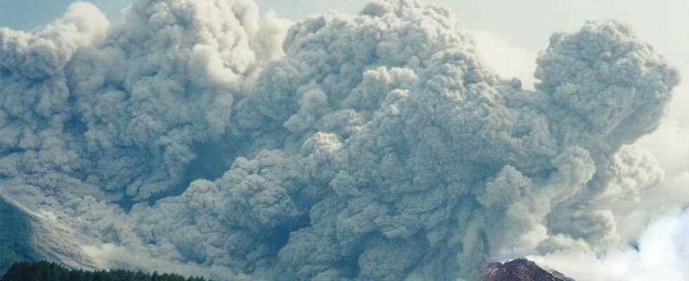
Seventeen pyroclastic flows spread over the southern flank of Mérapi on March 9 and 10. Until then, the eruptive activity was rather concentrated on another flank: the change in activity was therefore quite sudden, forcing the local authorities to evacuate 250 inhabitants in a preventive manner.
You will also be interested
[EN VIDÉO] Interview: what are the different types of volcanic eruptions? Volcanic eruptions are arguably among the most destructive and spectacular natural disasters. They take place all year round and almost permanently in various regions of the globe. Futura-Sciences met Jacques-Marie Bardintzeff, doctor in volcanology, so that he could explain to us how these eruptions take place.
For several months, the Merapi has a special feature: it maintains two lava domes simultaneously active! One is in the summit crater of the volcano and the other is on its high southwestern flank. If the first has been very moderately fed for a few weeks, the second is a little more and as this dome is unstable in the slope, this generates some pyroclastic and short avalanches fiery clouds sometimes on this side. As a result, the defined danger zone is seven kilometers from the summit in this southwestern sector, five kilometers to the south because the crater is open at this location and three kilometers on the other flanks of the volcano.
Tanggal 9-10 Maret 2022, Gunung Merapi meluncurkan 17 kali awanpanas guguran (APG) ke arah Kali Gendol. Ujung luncuran APG teramati di sisi tenggara bungker Kaliadem. Berdasarkan pantauan foto udara menggunakan drone, jarak luncur APG kali ini mencapai 4.9 km dari puncak. pic.twitter.com/8oBij0zADA
— BPPTKG (@BPPTKG) March 10, 2022
Satellite view of the southern flank of Mérapi and photograph of the area where the longest burning cloud of this episode stopped. © BPPTKG
Residents evacuated preventively
While the lava dome in the summit crater had evolved very little lately, part of it collapsed on March 9 and 10, generating seventeen pyroclastic flows in the Gendol ravine, south of the volcano, the longest reaching five kilometers! A distance that fits perfectly with the radius of the danger zone in this sector! Those collapses are they the consequence of a new supply of lava at this level? Or explosions that would have shaken the dome?
Be that as it may, for fear that the activity would intensify, the authorities decided to evacuate the inhabitants of the sector, inhabitants who no doubt still remember the fiery clouds of 2010 which covered more than 15 kilometers on this southern flank, causing over 300 casualties!
Deposit of burning cloud still hot in the Gendol ravine. © TRC BPBD KAB SLEMAN
This episode in Mérapi is rather curiously reminiscent of Monday’s in Fuego, Guatemala. Indeed, these two eruptions involve a mass of lava which, when it becomes unstable in the slope, can generate pyroclastic flowsthus threatening areas far from the eruptive center…
Interested in what you just read?