Yesterday, Tuesday, Russia announced its intention to change the territorial waters of the country in the Gulf of Finland. The announcement mentioned, among other things, the islands listed in this story.
However, Russia’s intentions are unclear. On Wednesday, the document that described the plan was removed from the Internet, and a Russian news agency reported that the state borders are not being changed.
Autiosaari Säivö and the lighthouse island Ruuskeri are in the middle of the Gulf of Finland
Before the wars, the islands belonged to Finland. Today, they are the westernmost corner of Russia after the Kaliningrad enclave.
Shade i.e. Pien-Tytärsaari is an uninhabited and low-lying island with a sandbar about three kilometers long.
Before the Second World War, Säyvö belonged to Finland, and lichen was collected from the island for the livestock of the neighboring island. Finland had to hand over Säyvö to the Soviet Union after the Winter War in 1940 in the Moscow Peace Treaty.
Rosemary is, on the other hand, a small lighthouse island, located 18 kilometers west of the largest island in the sea area, Suursaari. Ruuskeri currently has an automated lighthouse that was built on the island at the end of the 19th century.
The island is not inhabited. In 2008, a ship ran aground near the shore. Its crew was rescued, but the wreckage was left in place.
Nowadays, Ruuskeri is the westernmost point of Russia, if the enclave of Kaliningrad is not counted.
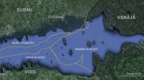
Suursaari is a Russian outpost in the Gulf of Finland
The most interesting of the islands in the area is Suursaari. In recent years, Russia has been active on the island and built a new radar station there.
Suursaari is the largest and highest island in the eastern Gulf of Finland, which is clearly visible from the coast of Finland. Suursaari is located only 35 kilometers from the port of Kotka.
The island is 11 kilometers long and its highest peak, Lounatkorki, reaches 176 meters above sea level.
Russia started equipping Suursaari after it seized Crimea in 2014. The satellite images published by show how Russia has built a radar station and an airport for military helicopters on Haukkavuori, located in the middle of the island.
Russian paratroopers and special forces have trained more on Suursaari than before.
According to ‘s report, Russia has probably used Suursaari for GPS jamming in March 2022. It has also affected Finnish air traffic.
Before the wars, Suursaari belonged to Finland and almost 800 people lived there.
The island of Somer is known for sea battles – Jähi is just a tiny rock islet
The island of Jähi is divided so that its southeastern tip belongs to Russia.
Summer is a small rocky island with a lighthouse, radio mast and buildings.
The kilometer-long Someri is located on the northeast side of Suursaari.
In the Winter War, the Finnish soldiers retreated from the island without a fight, and in the Continuation War, the Red Army did the same. In 1942, a major naval battle took place over control of the island. Soviet troops landed on the island, but the underpowered Finnish troops repelled the conquest attempt.
Freeze is a rather 200-meter-long uninhabited rock island that belongs almost entirely to Finland.
The national border cuts across the southeast corner of the islet. Next to Jähi are two even smaller islets, Pöysäri and Kivikartti, which belong to Finland.