Météo-France announces that the next few days could be the hottest of summer 2023. A new wave of heat which could flirt with 40°C, in particular south of the Loire. This rise in temperatures forecast from Sunday is expected to last at least until the middle of next week. This Friday, August 18, 28 departments are already on heatwave orange vigilance. The government convened an interministerial crisis unit the day before to assess the situation. A national information platform has been activated since this Friday: Heatwave Info Service can be reached on 0800 06 66 66, in parallel with prevention messages broadcast on television and radio.
Why is the summer of 2023 unusual?
This year, the northern half of the country experienced heavy rainfall and gloomy weather in late July and early August for the summer season. In question, the unusual behavior of the polar jet stream, initially too low for the season. This time, it is heading north and causing warm, stagnant air to rise towards France. The unusual fragmentation of this jet stream into two parts, a probable consequence of climate change, also prevents the creation of disturbances in Europe. Result: temperatures rise and drought sets in.
This heat wave surprises by its arrival during the third week of August. Such temperatures rarely occur this late in the summer. In France, there have been only six episodes of heat occurring after August 15 since 1947. Even during the deadly heat wave of 2003, temperatures had risen the first ten days of August. For meteorologists, this wave is also due to the formation of a heat dome.
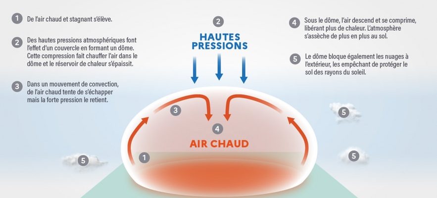
What is a heat dome?
Currently, the southerly flow is bringing up warm air from the Maghreb. However, the high pressures above Western Europe trap this hot air near the earth’s ground: it is this “blockage” that is called a heat dome. The expression, popularized in 2021 during a historic Canadian heat wave, describes the phenomenon well: a mass of air accumulates, trapped as if under a bell.
Diagram showing how a heat dome works.
© / Meteo France
This bell is an anticyclone, an area in the atmosphere where the pressure is higher than around. The air is compressed there and will therefore heat up and dry out. The downward movement of the anticyclones has a dissipative effect on the cloud cover and the associated precipitation, also guaranteeing dry and sunny weather. In France, it is often the Azores anticyclone that brings good weather in summer. However, in the case of the heat dome, the absence of atmospheric motion aloft blocks these high pressures indefinitely at the same location. The air mass, enclosed, becomes static. Heat therefore accumulates, with temperatures often dropping little at night. This greatly increases the risk of a heat wave (when the heat remains night and day, for at least 3 days).
What to expect in the next few days?
During this weekend of August 19 and 20, in addition to the irregularities of the jet stream, the Azores High will extend its influence towards France and Central Europe. Gradually, the heat dome will begin to form over the south of France and will accentuate the heat wave already underway in these regions. In Languedoc, the mercury should approach 40°C. This heat bell should persist and spread throughout France from Sunday and at least until Wednesday August 23. Temperatures should also remain high even at night (above 22°C).
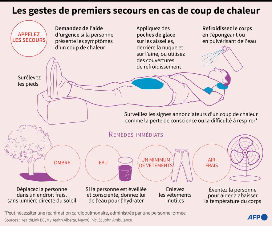
The first aid gestures recommended in the event of heat stroke.
© / AFP / GAL ROMA, PAZ PIZARRO
The north-east, on the other hand, should escape the most drastic effects of the “dome”, in particular towards the Channel and the coasts of Brittany. The return of the oceanic influence at the end of next week should finally destabilize the air mass and disturbances should sweep the heat dome. This transition is always violent and must therefore bring strong storms. From Thursday August 24, the anticyclone should thus begin to migrate towards the East and shift over the Balkans, gradually taking with it the scorching temperatures. Only the south-east could see strong heat persist, but the end of August promises to be cooler overall. In the meantime, the government recommends great vigilance in the face of the risks associated with the heat wave, such as dehydration and heatstroke.