Between a region affected by flooding and another affected by historic drought, there are only a thousand kilometers. Paradoxical and striking effect of an ever more disrupted climate, and growing tensions on the country’s water resources. Each summer now imposes its debate on its uses and access, while the sometimes torrential rains of winter ravage certain territories. How can France adapt to this new reality? L’Express wanted to contribute to a debate that is more necessary than ever. These six “black scenarios” for water by 2030 are the translation. They are neither forecasts nor predictions. But hypotheses on which public and industrial authorities are already working more or less directly, and whose frameworks have been refined and enriched by the forty experts interviewed: researchers, meteorologists, senior civil servants, engineers, insurers… All are unanimous: the The country’s resilience in the face of these events is being built now.
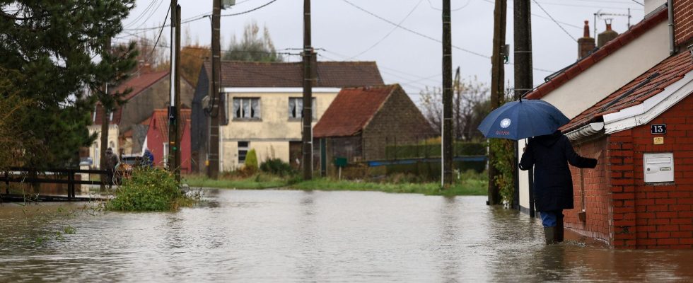
It all started with weeks of rain. Gray curtains which closed the horizon on this landscape of bocages and canals of the Dunkirk hinterland. Three months of almost non-stop precipitation. The inhabitants of Saint-Omer had not experienced this since the winter of 2023. We are in mid-January 2026, and the feeling of déjà vu is palpable: Météo France announces that Pas-de-Calais has gone into red rain-flood alert due to the risk of major flooding. Since the start of winter, the department has not fallen below the orange threshold. Disturbances followed one another in the Channel, driven by a series of depressions. Over the last three weeks, the cumulative rainfall across the department has exceeded the record level of 250 mm.
In this region of polders located below the sea, a network of valves, pumps and canals called “wateringues” was designed in the 1970s to respond to the problem of flooding. At high tide, the valves are closed, and open at low tide to allow the evacuation of water by gravity. This time, the means implemented are no longer enough. River flows are exploding. The Aa, the northern coastal river, which crosses Saint-Omer and Gravelines, is experiencing levels never before observed: while in 2023 volumes reached 90 cubic meters per second, this year they exceeded historical records. In the wateringues region, waterlogged soils can no longer absorb precipitation.
The outcropping water tables are overflowing. “During periods of flooding, evacuation depends 50% on pumping,” recalls Bertrand Ringot, mayor of Gravelines and president of the Intermunicipal Institution of Wateringues. The pumps are working at full speed, but the water volumes are exceptional. The villages of Saint-Momelin, Serques and Hesdigneul-lès-Boulogne have their feet in the water. Nearly a thousand firefighters, from all over France, are mobilized. More than 400 municipalities are recognized as being in a state of natural disaster, and insurers’ bills are exploding, approaching a billion euros… Climate change is also at the origin of local specificities. “IPCC projections show that we can expect greater accumulations of winter precipitation in the north of France in the coming years,” explains Matthieu Sorel, climatologist at Météo France.
Strong winds and a strong tide
During the second week of February, the wind added to the floods, which were just beginning to recede. Météo France placed the Nord department on orange alert for violent winds, but forecasters quickly noted that the anticipated depression had strengthened. The concern is major: as in 2013 during storm Xaver, the much-feared scenario of a combination of violent winds and a strong tide occurs.
After hitting Belgium and the Netherlands, gusts reaching 180 kilometers per hour sweep across the North. With a tidal coefficient of nearly 100, a surge phenomenon – a rise in sea level caused by swell and wind – hits the territory. “Luckily, in Boulogne-sur-Mer or Dunkirk, the maximum surge always occurs a few hours before high tide, which protects us a little,” notes Arnaud Héquette, researcher at the oceanology and geosciences laboratory. from the University of the Littoral Côte d’Opale. In Dunkirk and Gravelines, the dikes erected decades ago are under severe strain. At times, “packs of sea” break above. But the reinforcement work made it possible to avert the danger of a breach in the structures, as in 1953 in Dunkirk. “The current dykes have been consolidated to withstand a hundred-year level, plus an elevation,” reassures Olivier Caillaud, head of the sea defense service at the Côte d’Opale metropolitan center. Dunkirk had a narrow escape. Specialists have learned a lesson from this: risk projections for 2100 will also have to be increased.
.