A Wallaceburg man says the placement of some maps on municipal trails give people a wrong sense of direction, but Chatham-Kent’s parks director insists their method is the standard for public spaces.
John De Santis, who moved to the area from Hamilton over two years ago, said he noticed these issues with the trail signs about a month and a half ago. The maps are designed correctly, but De Santis said he has a problem with how they are staged.
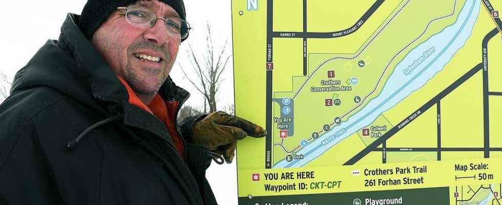
If someone were to face one of the signs at Crothers Trail, they would be facing south. The map has north pointing upwards on the map, so north would be to the visitor’s back. De Santis said the map should be turned around to the opposite side of the stand.
“In my opinion, this should be on the back side in order to be read correctly,” he said. “They’re (the municipality) telling me if you’re coming in off the street you should be able to read the map.”
De Santis said he also takes issue with a sign at Glen Mickle Fit Trail for a similar reason. In that case, someone would roughly face east while looking at it, but north points upwards.
With another sign at the Glen Mickle trail, the visitor would face north while looking at it. De Santis said that map is installed correctly.
Rob Pollock, director of parks, recreation and cemeteries for the municipality, said placing north at the top of these maps “is standard practice amongst cartographers when installing maps in public outdoor spaces.”
“It’s kind of like you plant yourself inside of the map,” he said. “In Crothers Park, you would see the parking lot is behind you, so you understand, ‘North is behind me.’”
Pollock acknowledged this method “doesn’t meet 100 per cent of individuals.” He said some may be used to how apps like Google Maps shift north on the map depending on where the individual is heading.
However, he said map makers find that approach for maps in public spaces even more confusing.
“It’s not a written down rule, but it’s how they make signs in public areas because depending on where they’re located, you would have to alter the map every single time where you install it,” Pollock said.
The parks director noted the maps are posted “straight up,” so north is pointing to the sky rather than forward.
De Santis said he doesn’t agree with the municipality’s explanation.
“They’re insisting it’s installed correctly,” he said. “I know then, that they’re telling me to get a book, turn it upside down and read it.”