You may also be interested
[EN VIDÉO] Heat wave or heatwave: what’s the difference? In summer, we hear about heat peaks, heat waves and heat waves. The difference is not obvious, but it does come into play for weather alerts or health vigilance plans.
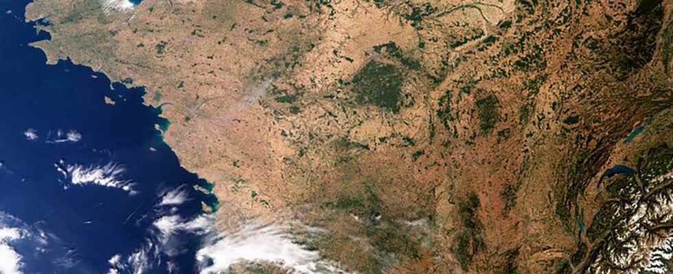
This satellite image of Sentinel 3 interesting that it provides a lot of information ” some of which are not visible to theeye naked “, explains Clément Albergel, researcher at the office of the climate at theESA (European Space Agency). You should know that Sentinel 3 has a “ radiometer that measures surface temperature “. It is not about the ” temperatureair in the meteorological sense of the term but rather the actual amount of radiant energy from the Earth – and which indicates the actual temperature of the earth’s surface “. Of course the high air temperatures are reflected in the temperature values of the earth’s surface.
Sentinel 3 has measured “ record temperatures, 48°C in the UK, over 60°C in Spain “. These Sentinel 3 measurements, “ combined with those of other instruments on board other satellites ofearth observation also measuring surface temperatures “, are useful for developing “ long time series Earth observations from space, and better understand how they evolve. This allows some kind of validating the climate models and some climate projections “.
The European Space Agency recently set up a database surface temperatures covering the period 1996-2020 which “ shows a stable increase in land surface temperatures on a global scale of 0.2°C per decade, with very strong regional variability “. This image of France, which shows a country covered in vegetation in a state of drought advanced, well illustrates the heat wave period and the succession of heat waves that affect France and Europe “.
These waves of heat which correspond to abnormally high temperatures, observed for several consecutive days, make ” part of the most worrying climate extremes with regard to the vulnerability of our societies “. These heat waves that we have been experiencing since June in Western Europe ” are the clearest signs of global warming caused by human activities, as shown by the various reports of the Intergovernmental Panel on Climate Change (IPCC) “.
They “us” provide insight into our future climate “, warns Clément Albergel
They “us” provide insight into our future climate “, warns Clément Albergel. The researcher would like to point out that the latest reports published by the IPCC “ indeed indicate that heat waves and, in general, extreme hydro-climatic events are increasing in intensity and severity. frequency because of climate change linked to human activities and in particular to emissions of greenhouse gas in the air “.
Conditions conducive to fires
As we see in the news (in Spain, Portugal, France, Greece, UK…), these extreme heat conditions and high temperatures are accompanied by conditions conducive to fires, ” i.e. low humidity in the air, low precipitation and drier vegetation create a high risk of fire as soon as there is an ignition source “. It has been shown that these conditions conducive to fires are observed more and more often over longer and longer periods of time “.
Added to this is another consequence of this succession of heat waves, ” associated with low rates of precipitation, it is the drought phenomenon “. Many rivers in Europe have now plummeted to record levels, which has serious repercussions on theagriculturea sector that consumes a lot of water for irrigation “.
Like every natural disaster and according to their characteristics (resolution, swath, revisit, spectral band, etc.), Earth observation satellites are quickly called upon to assess the damage and assist rescue. They are called upon to help their organization, provide logistical assistance to populations and anticipate the evolution of the natural disaster. In the case of fires, satellites make it possible to follow their evolution from space and above all to monitor different characteristics of fires such as ” dry and fire-prone areas, active and only smoldering fires, burnt areas, and smoke and trace gas emissions “.
Assessing burnt areas with satellite imagery has also as another interest to serve as a baseline to monitor forest regeneration “. If we put aside the notion of risk monitoring, it is also very “ important to develop long time series of burnt areas in the context of the study of climate change “, because when the vegetation burns, it ” releases a significant amount of greenhouse gases and particulate matter into theatmosphere. It is estimated that approximately 25% to 35% of greenhouse gases result from the combustion of biomass “. This is a variable that ESA is developing as part of its climate change initiative with the Biomass assignment. This satellite, whose launch is scheduled for 2023, will be dedicated to the observation and monitoring of forests, one of the most important natural resources of the Earth, in order to better understand the cycle of the carbon “.
To better understand the role of Earth observation satellites used to detect fires from space, it should be noted that this detection is based on two principles physical. The first is related to I’anomaly thermal that occurs when vegetation burns, involving a noticeable increase in the temperature of those areas on the ground which are significantly higher than those around them, they can then be reported as active fires. This signal is quite easy to detect, but generally lasts very little (a few hours, the time of the fire) “. The second possibility is to monitor changes in surface reflectance (the reflected light by our planet). These changes are due to the darker color of burnt vegetation, this scar left on the ground by the fires “. This signal is less obvious to spot from space but more “ permanent, especially in some biomeswhere the effects of fire last for several months or even years after the fire, although in tropical regions it may disappear within weeks “.
Better predict droughts and promote sustainable agriculture
To take into account climate change and its consequences, Copernicus, the European Commission’s global Earth observation programme, will be equipped with new families of satellites in the “ framework of the expansion missions of the Copernicus program “. As Clément Albergel confirms, “ notWe are working on the new high priority satellite missions of the Copernicus program “. Each of them will help to address the scientific, political and societal aspects of climate change, as well as the major environmental challenges expected, such as the sustainable agriculture management, food security, polar ice monitoring, and all will be used to understand climate change “.
Related to the topics of this article (heat wavedrought and fires), among these future missions, we can cite as an example the Land Surface Temperature Monitoring Mission (LSTM) which will embark a “ sensor infrared high spatial-temporal resolution thermal (enhancement of Sentinel 3) to provide global scale measurements of the temperature of the entire Earth’s surface, day and night “, as well as an instrument which ” will monitor the stress crop water supply at the field level and to support practicesirrigation more durable “.
Analysis of satellite data for mapping, monitoring and forecasting the Earth’s natural resources makes it possible to understand what changes are taking place, as well as when and where “. This mission will make it possible to respond more particularly to the needs of European farmers who must make agriculture more sustainable in ” a context of dwindling water resources and environmental changes “. Given the increasing scarcity of the waterhis ” use for agriculture will need to be more efficient “.
Interested in what you just read?