You will also be interested
[EN VIDÉO] Mars: fly over the Korolev crater! Fly over the frozen crater Korolev, located near the polar ice cap of Mars, as if you were there!
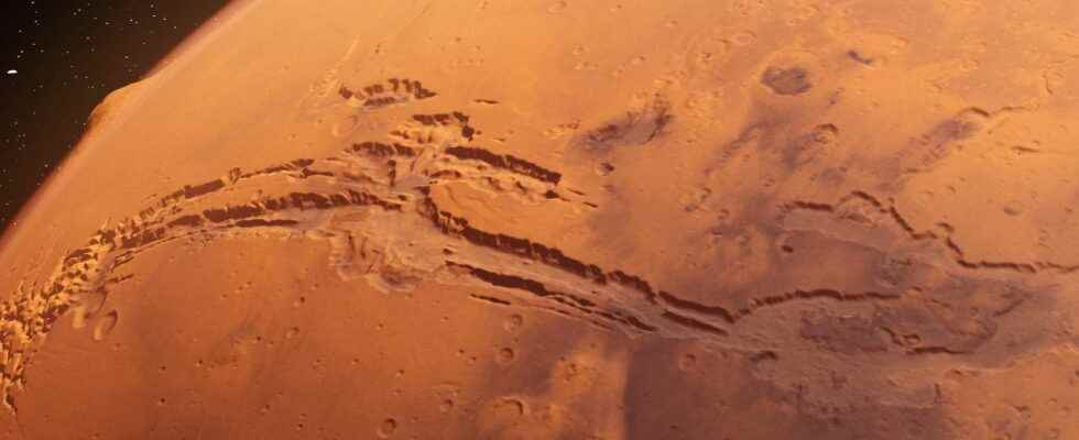
Our neighbor the Red Planet is not called Mars by chance, it is of course its red color clearly visible on theeye naked from Earth, which earned him the name of the god of war in Rome (inherited from Babylon and Greece). So when two millennia after Caesar, from 1962 to 1971, Mariner probes first unveiled details of Mars the likes of which had never been seen before, revealing a desolate, dry world, and sporting a huge gash long up close of 4,000 kilometres, how not to think of the face of a wounded warrior. Named Valles Marineris in honor of Mariner 9 who made his discovery, this impressive wound by its dimensions is none other than the longest, widest and deepest canyon in the Solar system.
Her formation would be related to the tectonic plate which tore at this location billions of years ago, leaving a very spectacular indentation which ends in the west with a network of valleys, the Labyrinth of Night. Here, in these images taken by the venerable European space probe Mars Express — she knows the Red Planet “like the back of her hand” since she has been flying over it for almost 20 years — we are not far from it, precisely to the east, in front of Tithonium Chasma and Ius Chasma canyons.
In the depths of Valles Marineris
On the walls of these two notches, one can observe the action of the wind which for billions of years has been the project manager of this environment, patiently eroding it, unlike the Grand Canyon on Earth (so much smaller), carved out by the Colorado River. Debris is piling up at the bottom, thousands of meters below. There, moreover, nothing is smooth or frozen too. There are many reliefs, of varying origins, such as mountains culminating at more than 3,000 meters, also streaked and plowed by the winds. Finally, reports the ESA, between these two mountains, there are bumps rich in ” minerals sulphates containing water »which keep the memory of the very old precious liquid in these deep gorges in places of 7 kilometers.
Mars is a paradise for geologists who read on these images of Mars Express and also from Mars Reconnaissance Orbiter the fascinating past of this planet close to ours.
In pictures: visit the Hebes Chasma Canyon
Article of Xavier Demeersmann published on October 17, 2013
Thanks to the images captured by the European space probe Mars Express (Esa), explore with an unequaled level of detail the reliefs of Hebes Chasma, a vast Martian canyon corroded by billions of years of erosion.
The red planet presents a wide variety of landscapes with which we are increasingly familiar. Moreover, it is not rare to meet some which echo what we know on Earth: here volcanoes, certainly giants, there valleys of debacles or dried up rivers. Without forgetting the canyons with disproportionate dimensions such as Valles Marineris, the most famous of the solar system, which stretches over nearly 4,000 km. An impressive scar on the face of Mars, perfectly visible from space.
The region has several scars, all likely formed during the first billion years of the planet’s history. For exogeologists, their origin is to be found in the uprising of the titanic volcanoes of the group of Tharsis Mountains dominated by the immense mount olympus, 23 km high and as wide as France. Stretched, the crust Martian would then have broken, indented in multiple points. Billions of years after this geological episode, we discover these gaping wounds transformed by erosion, thanks to the cameras of the orbiters present on site.
The strange canyon of Hebes Chasma on Mars
About 300 km north of Valles Marineris is Hebes Chasma (pictures above and below), another injury in the area. The canyon extends from east to west over some 315 km, and from north to south over 125 km, for a depth of nearly 8 km! Taking a closer look at the mosaic of eight highly detailed images, captured between 2004 and 2009 by the HRSC camera (High Resolution Stereo Camera) of the Mars Express probe, the scientists noted several interesting points.
The one that catches their attention the most is the long plateau, or mesa, remaining in the center of the depression whose summit is at the same altitude as the surrounding environment. The data acquired by MRO (Mars Reconnaissance Orbiter) of NASA and the European space probe show that its walls, apart from the materials of volcanic origin that are found buried throughout the region, are characterized by layers of sediments lakeand are carpeted with dust spread and moved by the trade winds or various landslides.
One of the curiosities of this damaged landscape is the horseshoe-shaped part, visible at one of its ends. On the rubble from a collapsed wall, we can make out a long flow of dark materials ending, below, in a strange puddle of black ink. It is not excluded that a sudden melting of ice or the effusion of underground reservoirs are the cause.
Impossible to miss the multiple furrows engraved on the slopes of the mesa, testimonies of the relative fragility of the rocks of the building. Their study revealed the presence of hydrated minerals, which only form in the sustained presence ofliquid water. A lake probably occupied this deep depression for at least several thousand years before disappearing. Subject to the erosion of windswater and landslides, the canyon of Hebes Chasma continues to grow.
Interested in what you just read?