In Norway, the authorities have issued a red, i.e. the highest level, warning for the southeastern part of the country.
Topias Peltonen,
Yrjö Kokkonen
At the beginning of the week, hot and humid air will arrive in Finland, which will quickly change to strong winds. However, the route of the incoming low pressure has remained so far south that the strongest rains and thunderstorms seem to remain on the Swedish side.
The whole situation is related to the same collision of warm and cold air masses, with which Europe has seen floods and heavy hailstorms since the end of the week.
– Warm air has come from the south and southeast, while at the same time cool air is arriving from the northwest. Whenever cold and hot collide like this, such situations arise at the interface, says ‘s meteorologist Anne Borgström.
A thunderstorm front was already approaching Finland today, which struck more than a couple of thousand lightning bolts on the Estonian side. However, after crossing it, the rains in the Gulf of Finland only fell to a couple of milliliters with a few flashes of lightning.
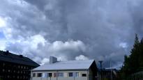
The most severe thunderstorms will move to Tuesday
During the coming night, there may be some thunderstorms in Western Finland as the warm front moves north. Southern Finland has a tropical night in some places, meaning the temperature does not drop below 20 degrees.
In the morning, the front is in Ostrobothnia, from where it moves further north during the afternoon. There may still be isolated thunderstorms in the central parts of the country.
Otherwise, the southern and central parts of the country are very hot, and the temperatures are around 30 degrees.
A cold front will push in late Monday evening and the night before Tuesday from the south, when a group of thunderstorms will arrive in the southern parts of the country. On Tuesday, a cold front will arrive in the central parts of the country, but according to Borgström, it is still difficult to assess the intensity of the weather phenomena.
– Thunderstorms are associated with the cold front, and there may also be hail and heavy rain.
Heavy rains are now threatening Sweden and Norway
Heavy rain is arriving over southern Sweden during Sunday evening. The Swedish Meteorological Institute SMHI has issued a warning for heavy rain and thunder for the whole of southern and central Sweden.
According to the forecasts, the Stockholm area in particular seems to get a lot of rain. According to SMHI, I can get up to 70 milliliters of water, for example Aftonbladet newspaper.
In Norway, the authorities have given a red, i.e. the highest level warning, to the southeastern part of the country, says public broadcaster NRK.
– The situation is very dangerous, says a hydrologist from the Norwegian Water and Energy Administration to NRK Trine Heggdal.
Water masses are feared to cause landslides in mountainous terrain.
Read more on ‘s weather pages.