The climate is bad over a large part of France: cold and sometimes rainy. When will this change? Meteorologists have the answer.
The beginning of August was not the most pleasant for the French, with heavy rain over a large northern part of France. Unstable weather is still forecast for the first ten days of August. But it could well mark the end of the rainy and windy summer, as a heat wave is approaching.
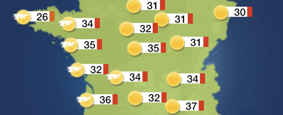
Thus, according to the weather forecasts of our colleague La Chaîne Météo, most cities in France will reach 32°C from August 11. And that thanks to the Azores High which is migrating towards us and it will start next week if all goes as planned. The gradual change is simply due to a change in air currents. Cool north winds at times are expected this week but warm/warm south winds will arrive later next week as the high moves towards us.” However, there will still be a risk of thunderstorms during the first half of the month. August, despite high temperatures.

Showers are likely to be expected for much of the territory in the coming days, locally heavy and stormy, with northwest or north winds bringing cool temperatures for the season. The showers may temporarily ease slightly, however there is a risk that this could give way to more inclement weather and strong westerly winds over the weekend. Beyond that, changing conditions are likely to dominate for the remainder of this period. Wet conditions are likely, along with the risk of longer periods of rain and stronger winds at times.
If you want to optimize your weekends, it is therefore best to book from August 11th. The weekend of August 5 and 6 could well be quite disrupted on Saturday. More beautiful on Sunday but with very cool temperatures for the season.