You will also be interested
[EN VIDÉO] 5 clouds to recognize to predict the weather For millennia, humans have learned to predict the weather through cues from nature. Among them, clouds can give a good idea of the short-term weather.
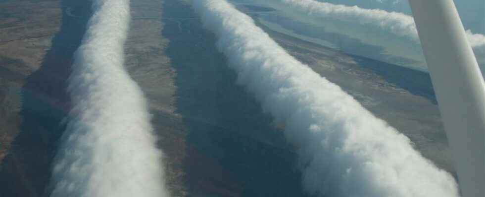
Morning Glory Clouds are formations that are rarely seen, but when they appear, images travel around the world all the time. These cloud tubes can appear solitary or in parallel groups. Each strip can be up to 1,000 km long, 1 to 2 km high, and travel at around 40 km/h.
They circulate at a very low altitude, 100 to 200 meters above the ground, which makes them even more impressive. Contrary to many clouds which deform while circulating according to the currents in altitude, the Morning Glory advances in a constant way without changing form and that, on hundreds of kilometers. The passage of each cloud tube is accompanied by a wind suddenly on the ground, at 40/50 km/h, which does not last more than a few minutes.
With the end of the dry season in Australia, the time of morning glory clouds returns. You can see it in the picture above, they are tube-shaped clouds. They can reach a kilometer high and a mile long. pic.twitter.com/q2DacGGuxs
— Fatima MEDDAHI (@fatima_meddahi) July 9, 2021
A cloud observable in September and October
They appear in the north of Australia, in particular in the Gulf of Carpentaria, at the end of summer and the beginning of autumn: September and October are the most favorable months for their observation, sometimes at the beginning of November as well. Why do Australians call them Morning Glory (“Morning Glory”)? Because these roller clouds generally form at thedawn, but not only. Some have already been reported in the evening, and even in the middle of the night. They were first described in 1942, in a report by pilots of the Royal Australian Air Strength. Their study only really began in 1979 and continues today.
The Morning Glory formation process is still quite mysterious, and the meteorologists Australians do not all agree on the various hypotheses put forward. The Morning Glory is not a arch of the same type as the one, also in the form of a roll, which occurs in front of certain storms, but it is similar to it.
It’s not often you get to see clouds like this from the ground, let alone the air!
This amazing video of Morning Glory cloud formations was captured by our Mount Isa crew as they were flying to Gregory Downs near the Gulf of Carpentaria. ☁️☁️ pic.twitter.com/0F0YkVA460
— Royal Flying Doctor Service (@RoyalFlyingDoc) November 7, 2021
Their presence in this specific area of Australia is linked to the relief, and to the microclimate characterized by changes in pressure sudden. It is a wave cloud whose formation depends on sea breezes: the air rises and cools, the humidity condenses and a cloud forms. But the currents specific to this zone bring down these cloud particles which evaporate, which would then give rise to this form of roll.
The Himawari-8 satellite had a spectacular view of the Morning Glory cloud rolling over the Gulf of Carpentaria this morning. pic.twitter.com/KjAa416mpI
— Ben Domensino (@Ben_Domensino) July 25, 2022
Some Morning Glory clouds have already been observed elsewhere than in Australia, but very rarely: in Uruguay, Mexico, the United States (Oklahoma and Great Lakes), Canada (Nova Scotia), Russia, Germany , and even on the Channel and Vendée coasts.
“Morning Glory” cloud along Lake Michigan in the United States. © Chad Bousamra
Interested in what you just read?