With Dynamic World, Google offers a spectacular tool to display the state of soils around the world on maps updated in near real time with unprecedented precision. An effective way to see the evolution of the planet.
The Earth is changing rapidly and radically. An evolution due both to climate change, which accentuates environmental phenomena, such as heat waves, storms, forest fires or floods, and to human activity, such as deforestation and urbanization, which denature the soil to the detriment of flora and fauna. Faced with these planetary upheavals, Google has decided to act. And to help researchers, scientists, economists, organizations and governments develop solutions, the American giant has just released a new free tool that is as innovative as it is amazing: DynamicWorld. Its goal ? Provide near real-time data on the state of soils around the world, thanks to satellite images and continuously updated maps. All with unprecedented precision, of the order of 10 meters. Enough to monitor the evolution of the surface of the planet continuously and analyze the ecosystems in place to make forecasts and establish effective plans, as explained by Google in his press release.
Created in collaboration with the World Resources Institute and powered by Google Earth and the AI Platform – an artificial intelligence using machine learning –, Dynamic World differs from existing tools, which are generally limited to a single type of ground “coverage” (constructions, vegetation, etc.) in a given area, with a monthly or annual updating rate. Google’s solution goes much further by making it possible to visualize real and current land use around the world, with an unprecedented level of detail and responsiveness. A technological feat, which requires the analysis and addition of some 5,000 satellite images per day…
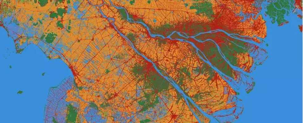
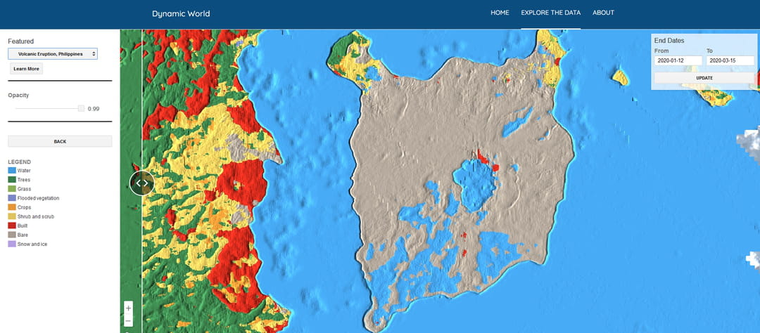
While Dynamic World is intended primarily for scientific use for study purposes, the service is accessible to everyone via a simple web browser. There is therefore nothing to prevent you from taking a trip there now, out of curiosity, to find out about and become aware of the evolution of the planet. Especially since, in principle, the tool looks a bit like Google Earth, which allows you to observe the Earth in 3D from your smartphone or computer, with such precision that it is possible to find your home. Again, you have to choose an area and zoom in to see it in more detail. For each parcel of approximately 100 m², Google displays the probability that the ground is covered by one of the nine types of elements identified, each being represented by a color code: water, submerged vegetation, urban constructions, trees, crops, bare ground, grass, and snow or ice. Better still, in addition to the current situation, Dynamic World allows you to see the evolution of the soils in an area over a specific period, by dragging a cursor over the image. And the results are truly stunning, as can be seen with the Taal Volcano eruption that took place in the Philippines in January 2020. All the trees and forests on the island were devastated, leaving behind nothing but soil naked covered with ashes.

By opening this tool to the scientific community and thus providing a gigantic cartographic database, Google is participating more actively in the preservation of the environment. The subject also seems to interest the Internet giant more and more, which, in a more practical and more daily register, has begun to deploy a new function in Google Maps to know the quality of the air. It is just to be hoped that Dynamic World will serve not only to raise awareness of the state of the planet but also to develop solutions to preserve it.