Storm Gérard hits the northern half of France this Monday, January 16 and 24 departments are placed on orange wind vigilance with gusts of 100 km / h and sometimes more according to Météo France.
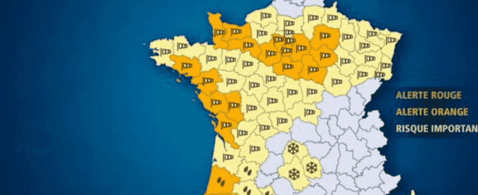
The winds are raging over the northern half of the country. While storm Gérard is due to cross France from east to west this Monday, January 16, 2023, 26 departments are placed on orange vigilance according to Meteo France. It is mainly the north-west and the Ile-de-France basin which show gusts of 90 to 100 km / h and sometimes up to 120 km / h or even 150 km / h locally on the coastal departments, which are also warned against to the risk of floods.
The winds from storm Gérard should gradually shift northeast over the course of the day according to meteorologists, but Météo France only extends orange vigilance until 4 p.m. on Monday according to the morning bulletin. The winds should also decrease in intensity from the beginning of the afternoon. A handful of departments have already left the perimeter of the storm, particularly in Brittany, in the Pays de la Loire and the east of the Center-Val-de-Loire region.
Which departments are on orange wind vigilance?
Météo France lists 26 departments in orange vigilance for wind on the passage of storm Gérard: Côtes d’Armor, Ille-et-Vilaine, Loire-Atlantique, Vendée, Manche, Mayenne, Calvados, Orne, Sarthe, Seine-Maritime, Eure , Eure-et-Loir, Pas-de-Calais, Loiret, Yonne, Aube, Marne as well as all the departments of Ile-de-France except Val d’Oise.
Two other departments are also placed in vigilance orange snow ice by Météo France in the Central Massif, namely Cantal and Lozère. In these territories vigilance is planned until 5 p.m.
According to The Weather Channel, we must add to this list three departments in rain vigilance with the Landes, the Pyrénées-Atlantiques and the Hautes-Pyrénées. Note that significant rainfall disturbance affects most of the country and often accompanies the gusts of wind from storm Gérard.
Transport disrupted due to storm Gérard
The winds that blow at 100 km/h and sometimes more than 150 km/h in France are not without consequences for the country. If motorists are urged to be careful on the roads and to reduce their speed, public transport is also affected by storm Gérard. In Ile-de-France, transport is not spared. The RER D is already experiencing difficulties because of “an obstacle (tree) on the track in the Villabé sector” which prevents traffic from Melun to Corbeil-Essonnes for up to 8 hours according to SNCF estimates. The RER E and line T4 are also slowed down because of other obstacles on the tracks. Traffic conditions are also complicated and the passage of trains is sometimes interrupted on lines R, P, L and J.
It is not only in Ile-de-France that transport is affected. The SNCF warned that “this exceptional weather event requires the adaptation of transport plans in Normandy” to “guarantee the safety of travelers and staff”. As a result, seven lines risk being severely disrupted: Cherbourg – Caen – Evreux; Le Havre-Rouen; Caen-Rouen; Caen-Le Mans; Caen-Rennes; Granville – Dreux and finally Fécamp – Le Havre – Rolleville.