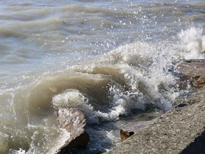
The Grand River Conservation Authority issued a flood warning early Friday evening following a high lake level advisory from the Ministry of Natural Resources for Lake Erie, particularly along the Grand River downstream of the Dunnville Dam in the Port Maitland area.
Environment Canada also issued a wind warning for several areas included Norfolk and Haldimand with a possibility of wind gusts reaching up to 90 km/h starting Saturday afternoon into evening.
Forecast strong winds, convective thunderstorms, and 15-20 mm of mixed precipitation may result in lake levels rising 1.1 meters above the current level between early evening Saturday and early morning Sunday in the Port Maitland area.
The Long Point Region Conservation Authority issued a Flood Watch for the Haldimand County shoreline, and a Shoreline Conditions Statement: Flood Outlook for the remaining shoreline areas within the LPRCA watershed.
“A significant weather system is forecast to bring high winds to the Lower Great Lakes Region tomorrow, Saturday, March 25, 2023,” said development technician Brady Baker. “Areas along Lake Erie will see winds from the east and southeast at 44 km-h up until afternoon on Saturday before changing directions to the southwest early evening.”
The high winds may increase water levels due to wave heights and storm surge with the potential to reach local flood thresholds in Haldimand County. Minor shoreline flooding, increased erosion, and wave uprush may be the result.
“Water levels in Long Point are expected to peak around 1.67 meters above chart datum over the next 24 hours,” Baker noted. “The Lake Erie shoreline wave height is predicated to be slightly over 1.5 meters for the eastern watershed while the central watershed will have waves ranging from 2.5 to 3.5 meters during this event.”
People, especially children and pets, are strongly urged to keep away from shoreline areas with elevated water levels and strong wave action.
The flood watch remains in effect until 8 am on Sunday.
Meantime, snowpack that is melting due to mild temperatures and rain — coupled with a mix of rain and snow forecast for Saturday – has prompted the Grand River Conservation Authority to urge caution around local bodies of water.
“No significant flooding is expected with this event,” said GRCA communication manager Lisa Stocco. “However, higher flows in local waterways will increase the risk in low-lying areas typically prone to flooding.”
While GRCA reservoirs will be help reduce downstream flooding, river flows will remain high.
People are urged to be cautious around rivers and streams.
The combination of cold, fast-moving water and slippery banks make walking in those areas dangerous, especially for children and pets who should be kept away.
The watershed conditions and safety statement will remain in effect until noon on Tuesday, March 28.

Comments
Postmedia is committed to maintaining a lively but civil forum for discussion and encourages all readers to share their views on our articles. Comments may take up to an hour for moderation before appearing on the site. We ask you to keep your comments relevant and respectful. We have enabled email notifications—you will now receive an email if you receive a reply to your comment, there is an update to a comment thread you follow or if a user you follow comments. Visit our Community Guidelines for more information and details on how to adjust your email settings.
Join the Conversation