You will also be interested
[EN VIDÉO] A billion years summarized in 40 seconds: plate tectonics Researchers have modeled the movements of tectonic plates over the past billion years.
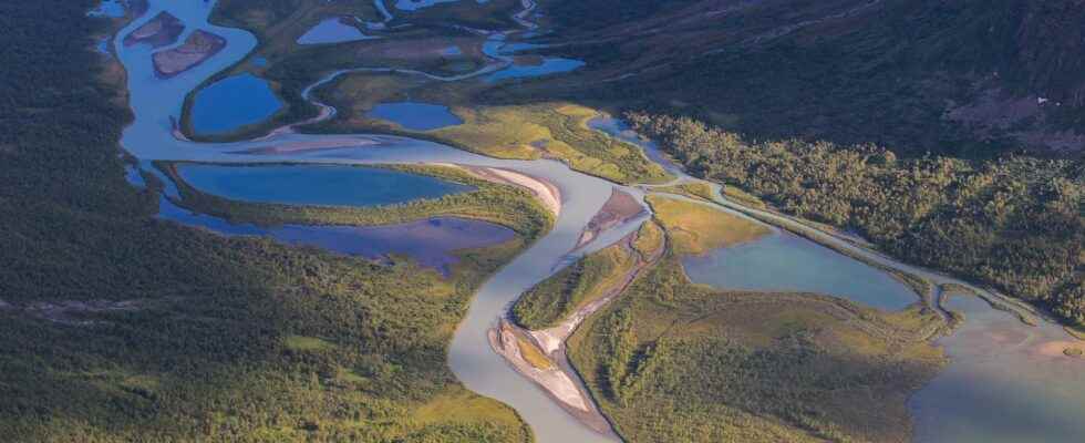
Among the major processes that shape the landscape, there are obviously tectonic processes, to which we owe the uplift of mountain ranges or certain trenches ofcollapse, but there are also erosive processes. the wind, snow, rain, rivers, temperature variations but above all watercourses – whether streams or rivers -, in fact contribute to the erosion of continental relief. While tectonic processes apply on a large scale and are only visible over the long term, except for the regular game of some flaws, the results of erosion are visible on a day-to-day basis and can lead to significant changes in the landscape over just a few years. The earth’s surface and topography are thus constantly remodeled and shaped.
Tectonics and erosion: two strongly coupled processes shaping our landscape
While tectonic processes and erosion act together to shape the landscape, they also interact strongly. Indeed, by planing the reliefs and moving the detrital material from theabrasion rocks, rivers redistribute the surface load that weighs on the continental crust. However, this redistribution associated with the erosion-transport-sedimentation chain generates strong stress variations within the continental crust, which can in turn generate tectonic movements. The modelization Numerical analysis carried out for many years on this theme thus shows to what extent surface processes influence tectonic deformation, and vice versa. Indeed, if erosion helps to locate the stresses on certain flawstectonic processes lead to the creation of reliefs, which will, de facto, promote erosion. However, these numerical data lack real calibrations. The links between the two types of process are therefore still very poorly constrained.
In a new study, a team of researchers set out to model the growth of faults under the joint effect of river erosion. The team focused on a particular tectonic context, which is that of continental rift zones.
Continental rifts: between tectonic and erosive processes
These regions are subject to extensive deformation, which leads to the formation of a collapse trench (or rift). The East African Rift and the Rhine basin are two typical examples. It’s about very first stage of evolution leading to the opening of a new ocean. The formation of a rift is characterized by the development of conjugated normal faults (facing each other), which will lead to the formation of a graben (ditch): the central part descends to form a basin in which sediments will be deposited, while the edges of the ditch will rise to form a small relief. These are called “fault shoulders”. It is an isostatic response of the continental crust, which reacts to the lateral discharge. This tectonic context is relatively simple, with the formation of medium-sized structures, around 200 kilometers wide. Extensive stress is often localized to a single major fault at a time. The fault recording the maximum deformation may however vary over time. It is indeed common to observe a relocation of the deformation on a new fault.
The continental rifts therefore go, by their morphologydevelop important hydrological systems, with streams and rivers eroding the slopes and depositing sedimentary material in the bottom of the basin.
The morphology of continental rifts is governed by the efficiency of erosion
By studying the fluvial systems in 12 rift segments, the researchers observed by modeling the evolution of the faults according to the efficiency of the erosive processes. The results, published in PNASshow that the deformation remains localized on the same fault twice as long in the case of an effective erosive action of the rivers compared to an ineffective action.
Erosion efficiency is associated with the speed of slip on faults and the resistance rocks. Inefficient erosion thus leads to a more pronounced relief, and therefore greater topographic constraints on the crust, which quickly leads to the formation of new faults outside the basin. Conversely, the more efficient the erosion of the reliefs formed by the faults, the more the duration lifetime of faults is important. In this case, we observe a migration of the deformation onto new faults inside the basin.
The final structure of the basin will therefore be clearly different between the two cases. The study shows how much erodibility and climatic conditions have an impact on the morphology of the landscape around us.
Interested in what you just read?