You will also be interested
[EN VIDÉO] Geology of volcanic systems – an invitation to travel Interviews dating from 2009 with Georges Boudon, physicist at the IPGP, and members of the team studying the functioning of volcanoes, from the generation of magmas to eruptions. The vocation of IPGP films is to open the doors of laboratories and to accompany scientists in the world of geosciences. This film is part of a series of 14 short format films which are an invitation to travel from the cosmos to the center of the Earth. Design & production: Medi@terre, IPGP – 2009
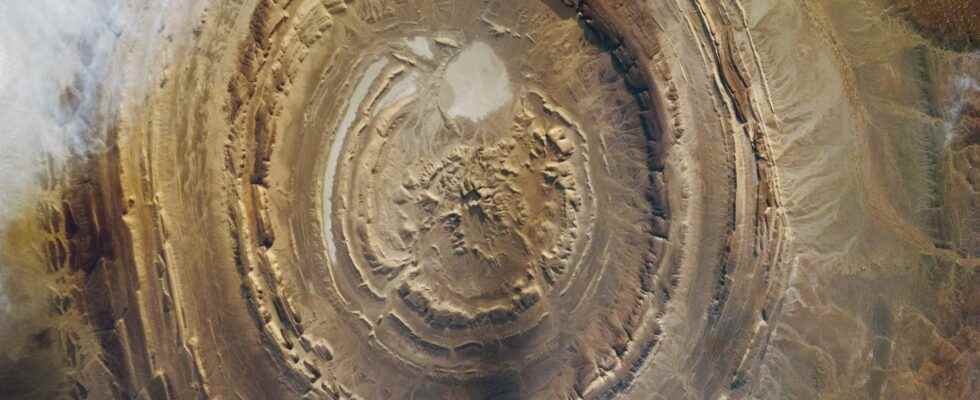
You have to take the height to discover this impressive geological structure nestled in the heart of the desert Mauritanian. Known as ” eye of Africa”, or Guelb er Richatthe Richat structure has often been the object of attention ISS astronauts who photographed it many times.
Measuring approximately 40 kilometers in diameter, the origin of this strange concentric structure lost in the middle of a desert landscape has long questioned scientists.
A magmatic origin
First described in 1916, the Richat structure has been the subject of many studies. First interpreted as the remains of a meteorite impact, the study of the rocks composing it shows that its origin is much more terrestrial. The concentric rings are indeed composed of strata oblique sedimentary. The center is formed intrusive (gabbros, carbonatites) and extrusive (rhyolites) igneous rocks. Although eroded, two ancient mouths eruptive can be observed. The gabbros are found in the form of two dikes concentric surrounding the rhyolitic center. Numerous other dyke and sill type intrusions have been identified within the structure. There is therefore no doubt that the eye of Africa actually has a magmatic origin. The dating of the rocks has also made it possible to date the event to around 100 million years.
Older sedimentary rocks in the center
But why this shape in concentric rings? To understand, you have to look at the rings created by the sedimentary strata. Because they give vital information: the age of the sediment decreases from the center towards the edges of the structure. This type of architecture is well known to geologists. It is an anticline: the sedimentary strata, flat beforehand, have been folded to form a dome, so that the oldest strata (originally the deepest) are found in the center of the structure. But to obtain the architecture visible today, it is necessary to wait for erosion to do its work. Over millions of years, the windsice and water have planed the dome, gradually removing the superficial envelopes to reveal the heart of the dome and therefore the oldest strata.
But while anticlines are generally the result of compressive tectonic forcesit is necessary here to appeal to magmatism to explain the formation of this structure.
A “bubble” of magma that lifted the sedimentary layers
100 million years ago, an important episode of merger generated an increase of magma which finally crystallized deep within the sediments. During its ascent, however, this magmatic “bubble” deformed the overlying sedimentary strata by lifting them, leading to the creation of a dome-shaped anticline. If some lavas have visibly succeeded in flowing out on the surface, the magmatism has mainly remained intrusive, not giving rise to the formation of a volcano.
Many archaeological remains have been found on the site, including Acheulean stone tools, dating from the early Paleolithic (1.76 – 0.13 million years). It is likely that the levels of quartzitea particularly hard sedimentary rock exposed by the erosion of the dome, were used temporarily for the manufacture of tools for prehistoric men living in the region.
Interested in what you just read?