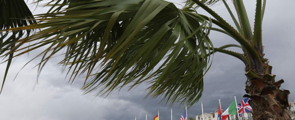
Winds of up to 110 km/h or more, blow on the south of France. If orange vigilance for strong winds have been lifted in the Southwest, they are still in force in the Mediterranean periphery. Details of forecasts.
The wind continues to blow violently on the south of France, but the phenomenon moves towards the east of the country. While they were placed in orange alert for strong winds since Thursday evening, the Haute-Garonne and the Tarn came out of the alert. Violent gusts, however, swept the region with gusts up to 120 km/h recorded in the Lauragais, as announced earlier by Météo France. Vigilance was lifted around 2 p.m. and the winds have given way to a rain-storing disturbances.
Several orange vigilances remain in order, however: the departments of Hérault, Gard and Bouches-du-Rhône are in turn alert for strong winds. The gusts should be slightly less powerful: “they reach 80 to 100 km/h, punctually 110 km/h are expected on the coastal strip and the interior close”, while inside the land “should reach 70 to 90 km/h frequent, and locally almost 100 km/h”, depending on the forecast. The wind episode should end in the early evening, around 7 p.m.
To the orange vigilance for strong winds are added three orange vigilances for the risk of waves-submersion in the eastern Pyrenees, Aude and Hérault. The alert must be active from 2 p.m. to 10 p.m. Friday, March 21. A direct consequence of the reinforcement of the winds in the regions of the Gulf of Lion according to the Meteorological Agency: “The wind is strengthening during Friday morning on the Gulf of Lion and then amplifies the state of the sea which becomes very strong. The strongest waves affect the coast of Languedoc Roussillon. Atmospheric conditions are also at the origin of a significant elevation of the sea level ( surfacle) “.
These vigilances sound the end of the spring weather of the last days with the arrival of a rain-leaning disturbance. In the Lauragais as in the Mediterranean, the episode of wind “gradually ends with the passage of a rainy forehead”, even rainfall. According to the meteorologist Guillaume Séchetthe showers could last on Saturday day and they could “turn to a punctual thunderstorm with a risk concerning a large part of the territory” French. “These thunderstorms should remain low to moderate,” said the specialist. Instability is also likely to be on Sunday on Sunday, despite decline in stormy risk.
Latest updates
18:30 – What forecasts for tonight and tomorrow?
At the end of the day, the storm will give way to an important rainy episode. “In the evening, a pluvio-stormy passage tackles our regions by the Mediterranean. This passage is accompanied by a significant drop in wind,” said Météo France. For this weekend, the conditions should calm down. Météo-France in its 4-hour balance sheet does not announce any orange vigilance department this Saturday, March 22. However, many departments are placed in yellow vigilance thunderstorms and a few on a vigilance yellow wind. “On the Cévennes, sustained rains persist. On Languedoc the sky remains very gray and rainy while some clearings are possible on Roussillon. A showers resist the West and turn to the storm in the afternoon, they extend from Occitania to the Paris region and Normandy in the afternoon”, foresees Météo-France for the day on Saturday.
15:24 – Peaks at 120 km/h in the Lauragais
It was in the Lauragais, between the Haute-Garonne and the Tarn that the most violent gusts were expected. Météo France has actually raised winds up to 120 km/h in Saint-Félix-Lauragais. Elsewhere gusts at more than 100 km/h have been recorded: 107 km/h in Castres-Mazamet, 107 km/h in Toulouse-Blagnac and 103 km/h in Muret.
14:49 – The waves -submersion alert activated until this evening
At 2 p.m., the orange vigilances in the face of the risk of waves-submersion were activated in the Pyrénées-Atlantiques, Aude and Hérault. It must remain in force until 10 p.m. Due to wind strengthening, these alerts coincide with the peak of the event in the Southeast. Winds to fall around 7 p.m., the swell should calm down a few hours later.
14:12 – Orange vigilance for violent winds reduced to three departments
In its 14-hour bulletin, Météo France lifted orange vigilance for the strong winds in Haute-Garonne and in the Tarn. The wind all the more fell after blowing in 90 and 120 km/h.
On the other hand, the alerts are still maintained in the Hérault, the Gard and the Bouches-du-Rhône with gusts which intensify reaching “80 to 100 km/h, punctually winds at 110 km/h are expected on the coastal strip and the near interior”. “More inside the land, the gusts of wind should reach 70 to 90 km/h frequently, and locally almost 100 km/h”, according to Météo France.
08:01 – 3 departments on alert for the risk of waves -submersion
The strengthening of the wind over the Mediterranean perimeter has led to the triggering of another orange vigilance in certain departments: those for the risk of waves-submersion due to the very agitated state of the sea. The orange alert concerns the Pyrénées-Orientales, Aude and Hérault between 2 p.m. and 10 p.m.
07:58 – Orange Vigilance Winds extended to 5 departments
There are no longer two, but five departments to be placed in orange alert for violent winds this Friday, March 21, according to the latest Météo France bulletin: Haute-Garonne and Tarn exhibited in the wind of Autan and now Hérault, Gard and Bouches-du-Rhône blown by the east wind. The alert must remain in force until the end of the day, around 7 p.m. according to the meteorological agency.