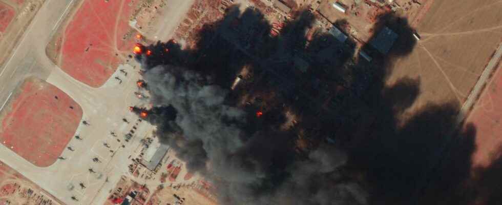
We bring you new satellite images of the war in Russia and Ukraine. Still provided by Planet, these images show, among other things, a new phase of the war with the clearly stated desire to target Ukrainian civilians, as evidenced by the destruction of the Mariupol theater, to destroy Ukraine’s industrial infrastructure, as can be seen with the methodical bombardment of the Azovstal metallurgical plant in Mariupol. These images also show Ukrainian attacks, in particular against sites that fell into the hands of Russian forces such as Serpents’ Island or Kherson airport.
You will also be interested
[EN VIDÉO] Spy satellites: mission to the land of the stars Among the satellites placed in orbit around the Earth, several hundred would be spy satellites and this is not science fiction. Their mission is of a military nature, they are vectors with a strategic vocation.
War in Ukraine: satellite images that show us the reality on the ground
Article of Remy Decourt published on 01/03/2022
The first satellite images, acquired a few hours after the start of the invasion and the attack on Ukraine by Russia, do not show the full extent of the damage that the Russian armed forces have inflicted on Ukrainian military infrastructure. However, we can see the first impacts of missiledestruction of buildings and equipment, or Ukrainian acts of sabotage, of bridges for example.
Never has an armed conflict between two nations been so closely followed and mediated by a multitude of satellites.earth observation commercial and private. These satellite operators and Earth imaging companies provide intelligence and information to everyone – previously only governments had access to it and they very rarely made it public.
Welcome to the era of New Space
This conflict highlights the role of these constellation satellites whose images show in near real time the conflict between Ukraine and Russia and the reality on the ground – official speeches or propaganda policies are now forced to take this into account.
But, let’s not forget, all these satellite operators are in the market to sell geospatial data with high added value. However, if the images broadcast free of charge to the media and the general public show the abilities of each other, you should know that they are capable of much better!
Let’s take the example of the wide-field images provided by Planet. At first glance, their main interest is to cover a very large area by offering resolutions up to 50 centimeters! But did you know that Planet is able to image the entire land surface every day and can observe the same place at different times of the same day, in different spectral bands. We let you imagine all the services that result from it. In the case of the Ukrainian conflict, Planet can observe in near real time the damage caused by the Russian forces, make an inventory of the state of the road, rail and energy distribution networks, identify the Russian forces but also detect small-scale changes or offer video or images in relief.
Russia-Ukraine: satellite images of the brewing conflict
Article by Rémy Decourt published on 02/24/2022
Some “wide field” images acquired by the Earth observation satellites of the Planet constellation which show the impressive deployment of Russian forces on the borders of Ukraine.
Earth observation satellites, whether civil, scientific or military, are at the forefront of observing the deployment of Russian forces near the borders of Ukraine. If the satellite images of the most powerful military satellites, whose details can reach only a few centimeters, are obviously not made public, private companies do not hesitate to show the reality on the ground.
Indeed, these companies, essentially American, have a fleet of several satellites in low orbit and broadcast almost daily numerous images of military activity around Ukraine as well as the impressive deployment of Russian forces which has begun at thefall 2021.
Military space data accessible to everyone
This is notably the case of the company Planet which provided us with some of the satellite images it acquires every day. Some of these images have a resolution of 50 centimeters, which makes it possible to see objects of only 1.20 to 1.50 m! The images provided by Planet are perhaps not those which offer the best resolution but, thanks to the details which it is possible to observe and, especially with the repetitiveness of the observations, it is possible to have a global view of Russian military power concentrated in doors of Ukraine as well as each of the movements Russian units.
Interested in what you just read?