You will also be interested
[EN VIDÉO] How does magma form before a volcanic eruption? Magma is the origin of the formation of volcanoes. This molten rock, which bubbles up in the crater, comes from a partial melting of the Earth’s mantle. Futura met Jacques-Marie Bardintzeff, doctor in volcanology, who tells the origin of magma.
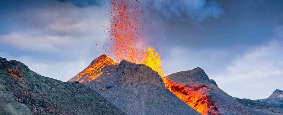
The Icelandic eruption continues, with no major changes since its inception. Despite everything, it follows a classic evolution for a fissure eruption, with the maintenance of activity on a few explosive vents of the initial fissure, which had many at the start of the eruption.
On these few vents, the explosive activity is modest, with fragments of lava that do not exceed twenty meters. Those that fall on the east side of the fissure pile up on top of each other and begin to build up a relief, what is called a “spatter rampart”. On the other side, on the other hand, these fragments fall back on the lava in movements who embark them: the vents therefore remain open towards the west.
Comparison of satellite images showing where the eruptive fissure opened up, at the northern end of the Meradalir Valley.
Photos showing the start of construction to the east of the fissure by the volcanic projections which fall back and are welded to the previous ones. To the west, the lava evacuates and forms a lava pond
Most of the lava that comes to the surface forms flows. These lavas first accumulated at the end of the Meradalir Valley where the eruptive fissure opened. The relief being very flat, the lava stagnated there and formed a lava pond. Then, the latter eventually overflowed to the southeast, causing a lava flow that reached the eastern end of the Meradalir valley.
For now, these lavas are covering last year’s lava field. The Icelandic scientists ran a model of flow spreading as a function of relief and showed that if the debit and the eruptive situation remains unchanged, the lava will not even reach the road that runs along the southern coast of the peninsula after 200 days of eruption! Proof that the eruption is really located in an almost deserted area!
Superb images filmed on the morning of August 5th. © Marco DiMarco
An eruptive site under surveillance
The eruptive flow, estimated at about 32 m3/s at the beginning of the eruption, quickly decreased and is around 18 m3/s. This is four times greater than last year’s flow estimated after a few days of activity, although it is still a fairly modest flow for an Icelandic eruption.
Consequently, the amount of gas emitted into the atmosphere is greater than last year. When there is wind, these gases are carried away and can disturb the inhabitants of the villages and towns of the Reykjanes peninsula, Reykjavik in particular. And when the weather conditions are calmer, these gases will stagnate around the eruptive site, especially in the valley bottoms, which can be problematic for the many curious people who come to enjoy the show!
Another risk for these people is the possibility that new eruptive fissures open, if the current eruptive site does not make it possible to evacuate all of the pressure in the volcanic conduit. This had happened several times during the eruption last year. Local scientists flew over the area with this in mind.
And then there are always the risks associated with poor weather report that should not be underestimated in Iceland. This is also why the authorities have decided to close the site for this day on Sunday. The webcams also attest to poor conditions… But open theeyewhen the clouds disappear, the show will return!
For those who wish to understand the classic course of a fissure eruption (here, Piton de la Fournaise), this DVD, produced by the author of this article, is made for you!
Volcanic eruption in Iceland: follow its evolution live
The intense seismicity that began last weekend was therefore not yet another “blow for nothing”. Since Wednesday August 3, around 1 p.m. (local time), an eruption began in Iceland, on the Reykjanes peninsula, not far from the site of the last one. The associated risks are very modest for the moment… The images are still spectacular!
Article of Ludovic Leducpublished on August 5, 2022
It was around 1 p.m. (local time) on Wednesday August 3, 2022 that the webcam scanning the site of thelast year’s eruption allowed to notice an alignment of lava fountains of about twenty meters high on an eruptive fissure 200 or 300 meters long. It opened about two kilometers northeast of the site of the last eruption, north of the Meradalir valley… This webcam allows you to follow the activity live: it’s really royal!
An eruption without too many risks for the population
It’s a eruption fissural, with a very modest explosiveness and the predominance of flows of wash which, already, spread out in this valley. As a result, the risks are very modest for the Icelandic population, the road bordering the coast being more than four kilometers away and Reykjavik, the capital, more than 20 kilometers away! Grindavik, the nearest village, is on the other side of Mount Fagradalsfjall, as is the power station which supplies much of the electricity to the Reykjanes peninsula and the capital region! Above all, it will be a wonderful spectacle, and the many tourists on the island should provide us with beautiful images!
Follow the live eruption of the volcano in Iceland. © mbl.is, YouTube
Interested in what you just read?