This Thursday, February 8, a new volcanic eruption is underway in Iceland on the Reykjanes peninsula, the third since December.
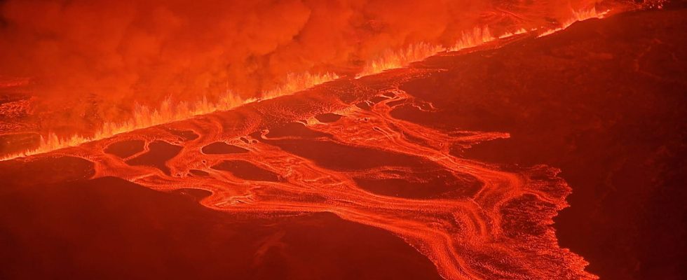
This is the third time since December 18 that the Reykjanes peninsula, in the southwest of the island, has been hit by a volcanic eruption. The Icelandic Meteorological Office (IMO) said on Thursday that at “6:30 a.m. [heure de Paris] This morning, a small earthquake began to intensify northeast of Sylingarfell. About thirty minutes later, an eruption began in the same area. The current eruption is taking place in a fissure “about 3 kilometers long” as specified by the IMO.
In total, Iceland has recorded six volcanic eruptions in two years. The latest took place on January 14 near the small town of Grindavik which has 4,000 inhabitants. The island has a total of thirty-two volcanoes or active volcanic sites, making it the most volcanic region in Europe.
Nearby World, Icelandic President Gudni Johanesson said that the Reykjanes region had not experienced such volcanic activity for 800 years. Faced with this renewed activity, the country is forced to rethink its infrastructure. For example in Grindavik, while the town was evacuated on November 11 in anticipation of a new eruption, dikes are being built around a power plant to protect it in the event of new volcanic activity. As Vidir Reynisson, head of civil protection, explains to Le Monde, the aim of these constructions is to divert the lava.
The lava jets are visible even from the Icelandic capital, Reykjavik, located further north. The images show that the lava extends onto the road closest to the volcanic site, causing the tar to melt. The IMO also added that “The lava jets reach a height of approximately 50-80 m and the plume rises to a height of approximately 3 km.” The institute said that the lava flow appears less dense than during the December 18 eruption.