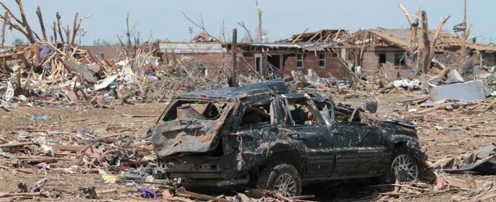
The United States was affected by a historic disaster of extreme violence, this Friday, December 10. More than 50 tornadoes swept through 9 southern and eastern states in the middle of December. The exceptional heat and the La Niña phenomenon played an obvious role: analysis of the climatic conditions that led to the disaster.
You will also be interested
[EN VIDÉO] A powerful computer-recreated tornado Concerned about the hundreds of tornadoes that plague the central United States each year, researchers in that country are trying to better understand the formation of these devastating monsters. Scientists have reconstructed with a supercomputer the tornado “El Reno”, one of the most powerful ever observed, which struck Oklahoma on May 24, 2011. It destroyed everything in its path over more than 100 km for nearly two hours … Grace with this simulation, we can better identify the phenomena at work.
In recent days, the United States has been swept away by a series of destructive tornadoes, unprecedented at this time of year. With 50 to 60 tornadoes reported Friday December 10 and more than 80 dead to date, this is theoutbreak deadliest tornado in 10 years, since the Joplin tornado in Missouri on May 22, 2011 that killed 158 people. How to explain phenomena weather report so powerful and destructive in the middle of a meteorological winter?
The weather conditions necessary for the formation of tornadoes
On average, 1,000 to 1,200 tornadoes are recorded each year in the United States, the country in the world most affected by these ultra-violent phenomena. Tornadoes only form under the most violent storms, supercells. Those thunderstorms occur under conflicts of air masses, when humid and warm air rising from the Gulf of Mexico meets cold air of polar origin: the meeting of these two air masses creates an explosive situation, very common in the USA in spring and summer, but can also sometimes occur in autumn and winter.
This is the situation that occurred last Friday and Saturday in the USA: thunderstorms broke out on this line where the two air masses meet. After plunging over the United States, the cold front moved east, confronting the heat unusual in southern states. Associated with strong wind shears (of different directions and directions) under the jet stream, this great instability of theatmosphere generated the most powerful category of thunderstorms in existence, supercells, characterized by their movement rotation, which sometimes leads to the creation of a vortex, the tornado. You should know that one in 100 thunderstorms on average is a supercell in the United States, and one in 6 supercells on average produces a tornado in the United States.
It is on this meeting line in the middle of the two air masses that is the Tornado Alley, the alley of tornadoes, the area where the majority of tornadoes occur, during the tornado season (February to June, with a peak between mid-April and mid-May). But tornadoes do occur at other times of the year, even in the middle of winter, although this is less common. Tornadoes most often occur in the late afternoon, evening or early night because the Sun has had time to warm the atmosphere, and this heat is the fuel needed for severe thunderstorms.
Is global warming involved?
Among all the severe weather phenomena (hurricanes, torrential rains, high heat …), tornadoes are the most complicated to connect to global warming. No increase in tornadoes has been observed in the United States in recent years despite the obvious rise in temperatures: even more, since the historic year 2011 (in number of tornadoes and victims), the American weather services have even regularly observed tornado “deficits” over the past 10 years. There were, in fact, fewer tornadoes per year than the average, particularly in 2018. This tends to show that there are no more severe thunderstorms, nor more tornadoes, despite global warming.
However, changes were still observed in the distribution of tornadoes by season. The warmer atmospheric conditions of recent years have been conducive to moreoutbreaks (large number of tornadoes in a day) during the winter. December is traditionally the least “tornadic” month of the year because there is not enough heat and humidity, necessary for the creation of thunderstorms. Only the descent of cold air is still present in winter, but this year the weather situation is different.
Since the 1er December, the country is faced with exceptional temperatures with many heat records: in Montana, California, Texas, it has never been also hot in december since the start of the weather records, with temperatures 20 ° C higher than the seasonal averages, giving rise to a feeling worthy of July in the middle of December! We recorded 26 ° C in Memphis (Tennessee) and 32 ° C in Texas on Friday, December 10, just before the descent of the polar cold which caused temperatures to drop sharply, giving rise to this violent conflict of air masses. It’s this huge contrast, between a polar air inlet (which generated a blizzard over the mountains of Hawaii) and temperatures of over 30 ° C in the southern states, which created explosive weather conditions.
It is not possible to relate a single event, no matter how extreme, to global warming, it is rather the repetition of these events over several decades that constitutes a clue. The increase in waves heat in the middle of winter can be taken as an indication of the consequences of global warming. And when they are confronted with descents of cold air, these exceptional heat waves then increase the risk of severe thunderstorms and tornadoes. This is the link with climate change that can be envisaged, if this type of event continues to occur regularly over the next few years.
In addition, a change also seems to be taking place in the location of the tornadoes which form more towards the east, slightly outside the usual zones of the Tornado Alley (tornado alley). According to National Severe Storms Laboratory (the laboratory that studies severe thunderstorms in the US), we can therefore expect more tornadoes in winter, less summer, and more eastward – from Mississippi to Ohio, including the Kentucky which suffered the historic disaster on December 10. A change in seasonal and geographic distribution, but no more tornadoes than before.
The obvious influence of the La Niña phenomenon
The atmospheric phenomenon La Niña probably also played a role: the years marked by La Niña, a cooling of the waters of the Pacific which has consequences for the weather worldwide, are known to bring milder winters to the southern United States. According to a study published in Nature Geosciencein 2015, the La Niña years were marked by more instability in the eastern United States (as on the great plains of Kentucky), and therefore more thunderstorms, hail and tornadoes in these areas Winter. On the other hand, no consequences were observed during spring and summer during the La Niña years. Conversely, the El Niño years are marked by a lower number of severe thunderstorms and tornadoes. During the La Niña period, the jet stream also tends to fluctuate less, giving rise to anticyclonic blockages, marked by persistent heat, over the south (like Texas) in winter. These lasting heat in winter then favor the development of thunderstorms in the direction of northern Texas and east of the Great Plains. It is exactly this weather situation that has occurred in recent days in this area of the United States, a context typical of a La Niña year.
At the climatic, meteorological and atmospheric level, all the conditions were met for the creation of violent storms and tornadoes over this region of the United States.
Interested in what you just read?
.
fs11