Three departments are placed in red vigilance for “floods” France by weather and others are, for the time being, in orange vigilance this Tuesday, January 28. Showers are expected during the day before the passage of a third depression which is likely to worsen the situation.
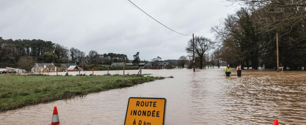
The floods continue in the northwest of France this Tuesday, January 28. Météo France has also extended red vigilance for “floods” to three departments: Morbihan and Loire-Atlantique were added to the Ille-et-Vilaine which is in the grip of intense rain and important floods Since the passage of the Eowyn storm last weekend. The Breton department has even observed unpublished floods with “exceptional levels observed on the Vilaine and the cuttlefish”. The floods have been of an unprecedented scale for 40 years and will take time to absorb: “The decline will be slow and will probably not start before Wednesday,” said the mayor of Rennes, Nathalie Appéré, in a statement on Monday. In addition to red vigilance, four other departments are on orange alert for “floods”: Calvados, Orne, Mayenne, Maine-et-Loire.
For Tuesday, January 28, 2025:
???? 3 departments in red vigilance
???? 5 departments in orange vigilanceFor Wednesday, January 29, 2025:
???? 3 departments in red vigilance
???? 4 departments in orange vigilanceStay cautious and informed:https://t.co/jgz4rtuvhp pic.twitter.com/2xqtjnwxyp
– Vigimétéofrance (@vigimeteofrance) January 28, 2025
The situation should not, or little, improve in the coming hours. New showers are expected this Tuesday in the northwest of the country, notably Brittany, “but the cumulative people should remain fairly low” and limit their impact on the floods prevents the Vigicrues agency. In Ille-et-Vilaine, water levels must “stabilize and orient themselves slightly downwards at the end of the day”, especially in the cuttlefish and the mid-median. But elsewhere, the propagation of the flood risks achieving the ugly downstream “exceptional levels […] From the night from Tuesday to Wednesday “. The floods continue to spread in Normandy and on the Pays de la Loire with the Orne and the Oudon, but the Meteorological Agency does not provide” significant aggravations “for Tuesday.
The floods reinforced by a new storm?
After Eowyn and Herminia, a new storm approaches via the south of the Atlantic. IVO depression could touch the northwest of France during Wednesday and bring “a new rainy episode” which “depending on the location of the strongest precipitation” could lead to “aggravation of certain current floods”. Red and orange vigilances active this Tuesday are currently maintained for the day of Wednesday January 29.
Latest updates
08:20 – What are the rivers affected by red and orange vigilance?
Météo France has placed seven departments in red or orange vigilance for floods, but these alerts relate mainly to rivers and therefore sectors in particular. In occupation, red alerts concern the cuttlefish and the Vilaine (median and downstream) in Ille-et-Vilaine. Vilaine also crosses Morbihan and Loire-Atlantique.
The other rivers targeted by orange alertness are ugly upstream and furniture (Ille-et-Vilaine), Oust (Ille-et-Vilaine and Morbihan), Oudon (Maine-et-Loire and Mayenne ), the medium and downstream Orne (Calvados) and the upstream Orne (Orne).
01/27/25 – 23:33 – End of vigilance Tuesday morning for certain departments, but the floods will last
If the orange alert for waves-submersion runs from midnight at 6 am on Tuesday and the avalanches vigilance from midnight to 9 am, the weather alert for “floods” could play the extensions well. Flood vigilances are generally maintained much longer than a rain-in-rod alert which would benefit from wind to push precipitation further for example. The water must flow in the rivers and be absorbed by the earth.
01/27/25 – 22:35 – A department on red vigilance and 14 others on Orange alert Tuesday
In its last evening bulletin, Météo-France maintains its various alerts for Tuesday. This January 28, Ille-et-Vilaine will remain in red vigilance for floods while 14 other departments will be on orange alert. Some for floods, others for waves-submersion, throughout the Atlantic coast, from Finistère to Pyrénées-Atlantiques, or even avalanches (Hautes-Alpes).
For Monday January 27, 2025:
???? 1 red vigilance department
???? 9 departments in orange vigilanceFor Tuesday, January 28, 2025:
???? 1 red vigilance department
???? 14 Orange vigilance departmentsStay cautious and informed:https://t.co/jgz4rtuvhp pic.twitter.com/h1qdoslftv
– Vigimétéofrance (@vigimeteofrance) January 27, 2025
01/27/25 – 21:36 – When can we hope for a return to calm?
The northwest of the country has been put to the test in recent days. The Eowyn storm, followed by the Herminia storm, then a new disturbance on Wednesday … When can we hope for an lull? Météo-France estimates that if Wednesday and Thursday promise to be rainy for a part of the country, “we should find more calm conditions at the end of the week”, with however “a little cooler temperatures”, but which will remain “in conformity to seasonal averages “.
01/27/25 – 20:34 – A new disturbance already announced on Wednesday
In its forecasts, Météo-France announces “a new active disturbance” on Wednesday. She will arrive “in northwest of France”. “The cumulation could reach 15 to 30 mm, or even 40 mm in places,” said the meteorology service. The new disturbance should affect Brittany to Lower Normandy and Vendée. And this, “in an already saturated soil context,” warns Météo-France.