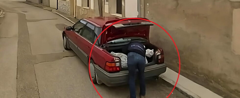
This is the unusual and horrible story that is making the buzz of the day. A suspect accused of murder was arrested using Google Maps: a Street View photo showed him hiding a body in the trunk of his car…
Be careful, Google is watching you! The Street View function, present in Google Earth and Google Maps, has more than once captured improbable scenes at the time the photos were taken. Indeed, hundreds of Google cars, equipped with 360° cameras on the roof, continually travel through cities and towns around the world to photograph the streets and allow users to virtually walk through them. And, sometimes, we can have a few surprises! A photo quickly went viral on social networks. It’s about a man putting a large bag in the trunk of his car, in a small village in Spain. As reported by the Spanish daily El Paísit could well help to elucidate a murder case…
Google Street View: suspect caught with his hand in the trunk
It all began with the disappearance of a man of Cuban origin in his forties in November 2023. A few months later, his body was finally found dismembered in a cemetery in the Spanish municipality of Soria, in Castile and Leon. . Unfortunately, the investigation is stalling, and it is impossible to find the culprit(s). But the matter could well be solved thanks to a cliché…
This photo was taken in the small village of Tajueco (Castile and León), Spain, which has only 56 inhabitants. The Google car surprised a man, leaning over his trunk, placing a very large white plastic bag likely to contain a corpse. Spanish police finally arrested two suspects on December 17: the victim’s wife and a man, presumably her lover, residing in the town of Tajueco. If the telephone tapping was decisive in arresting the two suspects, the photo would have been an important element in the investigation. It’s all the more incredible since the last photo of this street in Tajueco dates back to… November 2009. The suspects were therefore placed in detention. The investigation is still ongoing.

Google Maps: murder cases galore
This isn’t the first time Google Maps has been implicated in a murder case. In recent years, the service has provided valuable clues in several criminal cases. Thus, an image taken in 2011 in California already showed the body of a man on the groundwhile a police car was parked nearby. Similarly, in 2021, the police force in the state of Florida, United States, solved the mystery around the disappearance of a man in 1997 using Google Maps. In fact, a user spotted a car submerged in a pond on the mapping service. The victim’s remains were in the vehicle.
And that’s without counting when Google Maps itself is used to plan a murder! As reported SlateBrad Cooper, sentenced to life in prison for the murder of his wife in 2011, had planned the route on Google Maps to transport the body and make it disappear. For his part, Steven Hodgson, also sentenced to life imprisonment, had strangled an 85-year-old woman in the latter’s house, which was quite isolated. Among other clues, British police discovered that he had targeted his victim using satellite analysis of the surrounding area.
And what can we say about this couple coldly murdered at their home in Wisconsin in 2010. The son was convicted but still maintains his innocence. He assures that his parents were killed by mistake by a hitman who was actually supposed to kill the neighbor, a banker who had previously received death threats. The killer was allegedly misled by the wrong location of the house in a Google Earth photo. So you should always be wary of Google!
