All the factors in the weather in Finland are now tightening the frost.
Cold weather has prevailed in Finland since October, and in the last few days the weather has turned even unusually cold throughout the country.
Meteorologist at the Meteorological Institute Sini Jääskeläinen says that at the moment all factors in Finland’s weather are intensifying the cold.
According to Jääskeläinen, the essential factor is the polar vortex, which has “parked” over Finland.
The polar vortex, or the polar vortex, is a jet stream created every fall to a height of more than 20 kilometers, which circles the North Pole. The polar vortex keeps the very cold air mass of the polar region and the southern, warmer air separate.
The southern edge of the polar vortex is undulating and is now roughly level with Denmark and northern Ukraine, Jääskeläinen says. South of the rim, the weather is rainy and mild, but Finland is firmly on the colder side of the vortex.
At the same time, high pressure prevails in the lower atmosphere in Scandinavia, which makes the weather clear and windy.
In addition, there is snow everywhere in Finland, and the snow surface effectively radiates all thermal radiation into space, because there are no clouds in between, Jääskeläinen says.
All weather factors, from the earth’s surface to the upper atmosphere, therefore support freezing weather. Meteorologists speak of a low-level inversion, where cold air compresses downward. Already a few meters higher, the air would be slightly warmer, but the lack of wind prevents the air layers from mixing, Jääskeläinen explains.
Sudden warming in the direction of Siberia
According to previous forecasts, the weather in Finland would cool down a bit next weekend. Jääskeläinen looks at the latest weather data and warns that this might not happen.
A phenomenon is underway in the Far East and the Alaskan region that is splitting the polar vortex in two.
– At the moment, there is a sudden warming of the stratosphere, which is usually a preliminary stage for that [polaaripyörre] starts to break down. It is now underway in the Far East.
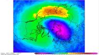
Sudden warming of the stratosphere is the meteorologist’s term for an event where heat is transferred from the lower atmosphere to the upper one, causing the thermal balance to be disturbed. The distribution of the vortex can be seen in the Wetterzentrale forecast of the German Meteorological Institute.
The breaking up or splitting of the polar vortex is not a rare phenomenon. That happens almost every winter, and at the latest in the spring when the northern hemisphere warms up.
According to Jääskeläinen, the breakup of the vortex seems clear. However, it is still partly uncertain what it means for Finland’s weather conditions.
According to Jääskeläinen, it is very possible that the second part of the vortex will stop over Finland and keep the weather cold until the end of January and maybe until February.
– According to statistics, January and February are always the coldest months of the year, Jääskeläinen reminds the ice lovers.