Reunion Island will go on a cyclonic red alert this Thursday, February 27 for the passage of the Garance storm likely to become an intense tropical cyclone. The phenomenon should spend less than 70 kilometers from the Reunion coast.
The island of Reunion^, already placed on orange cyclonic alert, will see vigilance to the higher level on the day of Thursday, February 27. The red alert will be activated between midday and the end of the afternoon, with a three-hour notice, due to the passage of the Garance storm announced the prefecture of the island this Wednesday.
The Garance meteorological phenomenon is still categorized as a tropical storm this Wednesday, but it has intensified in recent hours and should “benefit from environmental conditions favorable to its development” by Thursday. L’Reunion branch of the Météo France agency Considers that the Garance storm will reach “the tropical cyclone stadium (this Wednesday) at the end of the day or even in the evening (Saint-Denis time), before making a turn to the south towards the meeting”, according to its last Bulletin published at 7 p.m. (5 p.m. in Paris). The storm could still gain power and become an “intense tropical cyclone just before a passage as close as possible to the meeting on the night of Thursday to Friday”. The meteorological agency still warns that the chronology remains uncertain.
A passage less than 70 km from the coast
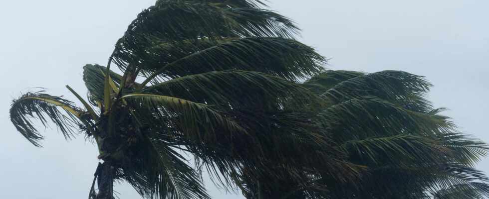
If the Garance storm was 370 kilometers from the Reunion coast during the last weather bulletin on Wednesday, the cyclonic threat remains direct for the meeting. The cyclonic phenomenon “should pass in the immediate vicinity”, that is to say between 50 to 70 kilometers from the coast, “or even on the meeting at the end of Thursday night”, anticipates Météo France. As a result, the degradation of weather conditions will be significant with heavy rain, gusts of winds at more than 150 km/h and a very agitated sea on all or part of the island. The weather channel Also evokes winds at nearly 170 km/h and gusts of up to 230 km/h. According to the same chain, the stormy winds already blow at 95 km/h and the gusts go up to 130 km/h at sea while the Garance storm is not yet at the cyclone stadium.
The cyclonic red alert is the third level of vigilance on a scale of four. When activated, total confinement is imposed on the population, with the exception of emergency services and the police likely to be called on interventions. The alert is given with a notice of three hours minimum before the start of the cyclone passage to allow residents to return to their home or their place of containment. It is recommended to call only in case of necessity, to keep informed and to wait for the alert before leaving. Before the cyclone passage, it is advisable to make water and food reserves.
The Garance storm follows a particular trajectory ranging from west to east, when almost all cyclones in the Indian Ocean are progressing from east to west to pointed out the meteorologists. Before the Garance storm and the linked cyclonic alert, the previous cyclonic vigilance concerning the meeting dates back to January 2024 with the passage of the Belal cyclone. At the time, the purple alert, the maximum level of vigilance, had been triggered prohibiting any displacement including for help and police.