The Location History Visualizer app lets you view your location history on Google Maps as a heat map. Another way to analyze your travels!
Most Android smartphones send your location at short intervals to Google’s servers. The Internet giant’s applications, installed by default, record everything: your movements, your routes, the places you have visited… They use the location of your smartphone thanks to the mobile’s GPS chip, but also to the 4G/5G network and the different Wi-Fi networks that you come across on your way. Google can thus know precisely where you are. This data is then analyzed for different purposes and is used among other things for Google Maps, for example to provide a history of your positions. A free application, called Location History Visualizerallows you to visualize this location data in the form of a heat map. This can be very interesting to have an overview and give even more relevance to the Google Maps timeline.
Location History Visualizer: an analysis of your Google Maps movements
Google Maps Location History is a very handy feature because it not only records your travel profile and most of the places you visited, but also photos of them. This allows you to get a more detailed overview of your schedule, see how many kilometers you traveled, or get a map of your travels over a selected period.
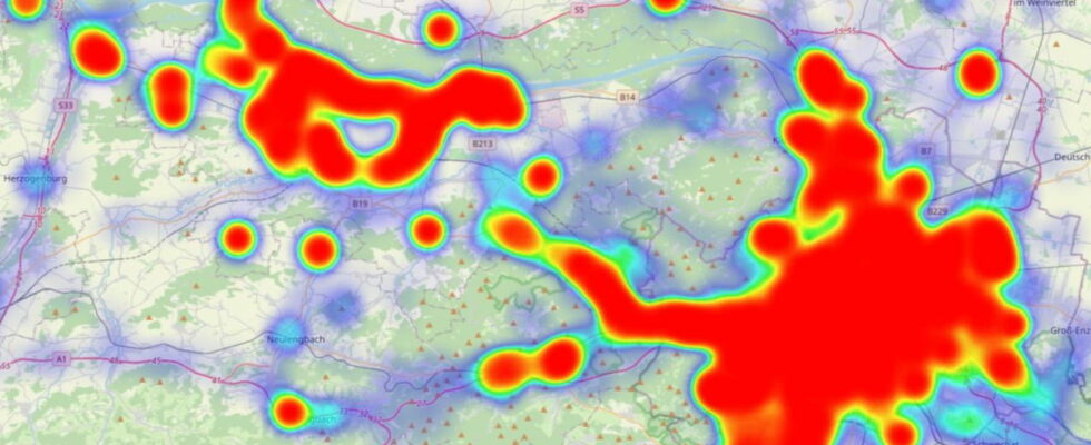
To go further, the Location History Visualizer tool focuses on the evaluation of logged locations. These are analyzed, weighted and then represented in the form of a heat map. On the latter, the usual representation of red to green tones allows you to see how often the different locations were visited. In the immediate vicinity of the home, there are many locations in dark red, while specific locations are marked with red dots. For example, if you like to eat out, the restaurant should also be topped with a red dot, but less dark than your place of residence or work.
To use Location History Visualizer, first download your location history data from Google Maps via Google Takeout and then submit it to the website, where it will be analyzed. Be careful: depending on how long Google Maps has been tracking your location and your activity, the file can be several hundred megabytes or even gigabytes. However, Google Takeout also offers a monthly archive with much smaller files, which are better suited for analysis. This is done offline, locally, so no data is sent to the provider’s servers.