If there is something that Thomas Pesquet can testify to, it is that in space, there is neither high nor low. And yet, in our collective mind, we still imagine the Earth with the north facing upwards. This exclusive representation prevails on all maps but also in all the images of the Earth that we see. Yet it has no physical value. This week, the Exploratorium is therefore interested in the origin of this universal convention.
You will also be interested
[EN VIDÉO] Why can’t we feel that the Earth is spinning? The Earth makes a complete revolution on itself in 24 hours, which corresponds to a tangential speed of 1675 km / h! Yet unlike a merry-go-round, we don’t feel the movement.
Imagine a planisphere representing the world with the South Pole at the top. This is what the Australian Stuart MacArthur did. A disturbing vision, where all our bearings are blurred. The world is turned upside down and we are totally lost. And yet this representation is no less valid than the one we are used to. The representation of the Earth is indeed very codified. The axis of rotation is always placed vertically, with north at the top and south at the bottom. We could however represent our Planet by positioning the axis of rotation horizontally. Strange, but why not?
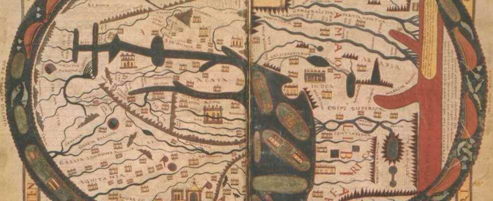
In the Middle Ages, the east, symbol of Paradise, was placed at the top of the maps
The cartographers of the Middle ages did not have the same rules concerning the representation of the known world. In general, the maps were drawn in a spherical form, schematizing the three known continents of the time in an orientation that may seem strange: Asia was then placed at the top, Europe on the left and Africa on the right. All bordered by an ocean barrier, limiting the known world. In this point of view, the east is therefore at the top, the north on the left and the south on the right. We are talking aboutOrientis Supra. And there is a good reason for this. The east in fact indicates the direction of the Sunrise, where Heaven is supposed to be. In the context of religious influence of the time it therefore seems normal to place this part of the globe in a higher position. The maps are moreover generally centered on the city of Jerusalem, marking a little more the predominant influence of the Judeo-Christian religion on the European graphic representations of the world.
In general, in all the societies of the Middle Ages, the important places (holy places, imperial palaces, most populated areas) were preferentially placed in the upper part or in the center. The less important territories being neglected in the lower part of the map.
Rediscovering the atlas of Ptolemy and setting up conventions
No universal convention then existed. Until the rediscovery of a major work by Ptolemy, entitled Geography. Cartographers from different regions of the world are interested in this work written around the year 150 and compiling the geographical and cartographic knowledge of the time of the Roman Empire. However, in this atlas, Ptolemy, as a good scientist, defines certain conventions, such as the fact of considering theequator as the basis of the latitude, but also the fact of representing the cards with north at the top. Fourteen centuries later, the new cartographers will therefore adopt this vision of the world, which will be reinforced by the increasingly widespread use of the compass, whose magnetic needle indicates magnetic north.
It was ultimately the Dutchman Gérard de Kremer, also called Gerardus Mercator, who made this representation a universal convention. In 1569, this mathematician produced one of the most important maps of modern geography. He builds a planisphere by applying a projection system, which, if it slightly distorts the contours of the continent, allows sailors to ensure they stay on the right course during major crossings of the Atlantic and the Pacific. A projection system still in use to this day and known as the Mercator projection.
This map, centered on Europe and presenting the north at the top in order to highlight the superiority of the old continent in the trade of the time had such an impact that it ended up endorsing this vision of the world, which is still topical. Only the Japanese continued to use their own system, centered on the Imperial Palace, until the middle of the 19th century.e century.
Interested in what you just read?
.
fs3