You will also be interested
[EN VIDÉO] The Moon as you’ve never seen it before! See the Moon in 4K through the eyes of the LRO probe. The latter, which has just celebrated its 10th anniversary, provides us with very detailed images of several regions of our satellite. Here, the Tycho crater and the slopes of its central mountain surmounted by a solitary rock; there, the vast network of craters at the south pole, inside the Moon’s oldest impact basin. A feast for the eyes. A walk to savor in full screen.
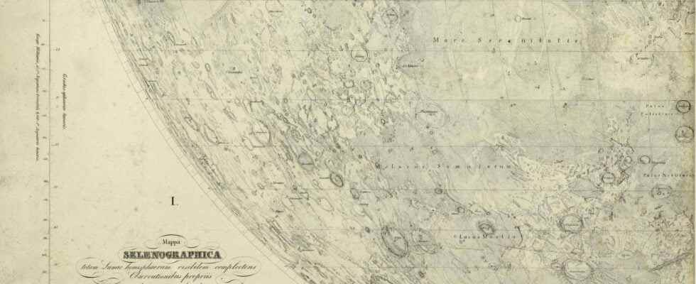
For thousands of years, the Moon has fascinated mankind. Object of belief, it appears in all cultures in multiple forms and its phases were quickly used, from prehistoric times, to mark time and structure social life. Star Inescapable of our sky, the Moon was then the object of predilection of the first observers of the sky. From the IIIand century BC, the astronomers Greeks determined the distance separating it from the Earth. At Ier century AD, Ptolemy calculates its orbit. But what fascinates most are the designs on its surface. at theeye naked, one can indeed easily discern darker forms, the forms of certain craters. Many myths have been projected into these imprecise tasks. Surprisingly, however, if some prehistoric representations of the Moon exist, no map dating from Antiquity or the Middle Ages has come down to us. The cartography of the Moon only really started from the XVIIand century, with the invention of the astronomical telescope. The Moon was then the object of precise descriptions, leading to the construction first cards. This is the beginning of selenography. Three hundred and fifty years before Niel Armstrong set foot there, the Moon was thus quickly described from all angles (those of its face upat least).
First Moon Race
Why such enthusiasm, so abruptly? The accelerated birth of lunar cartography will be linked to several reasons. The first is the need for more precise means of navigation. To get your bearings and stay on course on the high seas, navigators indeed need to know at what longitude they are. However, until the beginning of the XVIIand century, the calculation of the longitude is complex and imprecise. Around 1620, Michael van Langren, a Dutch astronomer and cartographer, suggested using the observation of lunar reliefs to determine the longitudes crossed. The construction of a precise map of the lunar relief therefore becomes a major political and economic issue, in particular for the major maritime powers. It was also a race for personal fame for the great astronomers of the time, who saw in this still virgin playground the possibility of inscribing their names in a topography visible to all of humanity. In a way, these are the beginnings of the great race for the Moon which will mark the end of the 20th century.and century.
The development of astronomical instruments
Observations of the Moon are however highly dependent on the quality of the optical instruments of the time. If we owe the first map of the Moon to William Gilbert (1544-1603), it is only a drawing made from observations with the naked eye. However, it has the merit of establishing a terminology, inspired by terrestrial geography, which will continue thereafter, such as the terms pond (Wed), oceanus (ocean) or land (Earth). The first to benefit from a model of astronomical telescope and to use it to carry out observations of the Moon is Thomas Harriot (1560-1621), English mathematician and cartographer. He thus produced a series of drawings highlighting the particularly rugged topography of the region at the edge of the illuminated area. Four months after Harriot, it’s the turn of Galileo, in November 1609, to make his first observations and drawings of the lunar relief. The results of his studies are the subject of a publication, Sidereus nuncius (messenger of the stars), who would become famous and contribute to Galileo’s fame throughout Europe.
Lunar cartography: political, economic, scientific and moral issue
Thereafter, the precision of the observations and the detail of the maps will go hand in hand with the development of astronomical instruments. To compensate for the gradual increase in focal length which makes it more and more difficult to manipulate the instruments, Jean-Dominique Cassini develops a tubeless telescope at the Royal Observatory in Paris. This technique allows him to observe much more distant stars, like Saturn and its satellites, but also to map very precisely the lunar reliefs. The invention of the telescope, then of the micrometer at the end of the 1660s, then makes it possible to precisely measure the size of the objects observed as well as the distance which separates them.
Mapping the Moon is also an opportunity to anchor certain human moral values and participates in the ideological stakes of this first race to the Moon. Thus, towards the middle of the XVIIand century appears the toponymy still widely used today: sea of the FertilityCrises, Serenity, Lake of Torments or Hope…
Interested in what you just read?