You will also be interested
[EN VIDÉO] A billion years summarized in 40 seconds: plate tectonics Researchers have modeled the movements of tectonic plates over the past billion years.
It is displayed in many classrooms and has accompanied us during the majority of our schooling and yet, we know it so little. The geological map of France is, however, an essential working tool for many companies, particularly in the sectors of regional planning, prospecting for mining and energy resources, water protection or the prevention of natural risks. It characterizes the French territory, schematizes the landscapes which surround us and contain the geological past of our regions. To study it is in a way to go back in time, but also to understand the origin of certain current events, such as seismicity.
Indeed, the geological map of France is rich in many details. Nature of surficial rocks, ages of units, topography, flaws… The first thing that jumps out eyes when you contemplate it, it is the diversity of geological units that cover our territory. Because metropolitan France is characterized by several major geological units. Can easily be distinguished: the Armorican Massif, two large sedimentary basins (Paris Basin and Aquitaine Basin), the Massif Central, the young mountain ranges of the Alps and the Pyrenees, as well as the Rhone valley, which crosses eastern France, from the Camargue in the south to Alsace in the north in passing through the Rhone Valley. Two other small massifs can also be observed: the Massif des Ardennes to the north, and the Vosges.
The Armorican Massif and the Massif Central: legacy of an ancient and gigantic mountain range
The Armorican Massif, which extends over Brittany, the western part of Normandy and the Pays de la Loire, as well as the northwestern part of the Poitou-Charentes region, is particularly visible on the geological map. It is a crystalline massif, a pale relic of two important and ancient mountain ranges: the Cadomian range and the hercynian chain (or Variscan). The Cadomian belt is very old and dates from 750 to 540 million years ago. The rocks of this age have been extensively reworked by the development of the Hercynian chain in Devonian (about 400 million years old).
This mountain range stretched over 5,000 km in length, with peaks reaching over 6,000 meters. It is the result of a series of continental collisions that led to the formation of the supercontinent Pangea. Delaminated by a phase of extensive tectonics and abraded by millions of years of erosion, this chain has nevertheless left a few other traces behind it. The Massif Central, the Massif des Ardennes and the Vosges are also relics of the Hercynian chain. The oldest rocks found today in the Armorican Massif are granite of age proterozoicsuch as the Saint-Brieuc granite (about 530 million years old).
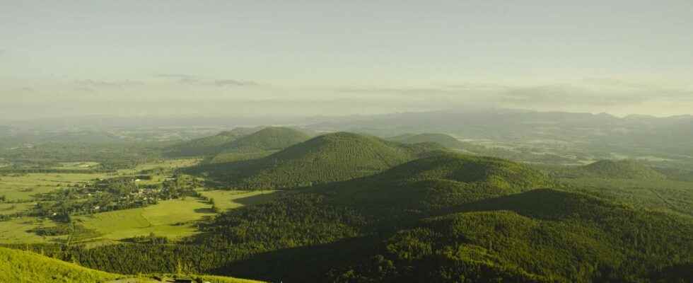
Although the region is home to an active volcanic complex until the Quaternary (6,000 years), the Massif Central is therefore also inherited from the Hercynian chain. Mount Lozère is a perfect example for studying the ancient rocks of the Hercynian basement. The volcanoes of the Puys chain illustrate well, for their part, the superposition of geological events over time.
Sedimentary basins: witnesses of ancient seas
Two major sedimentary basins, the Paris Basin and the Aquitaine Basin, are easily recognizable. These low-relief areas extend over a large part of central and northern France for the Paris Basin, while the Aquitaine Basin extends over a large part of the south-west regions to the Massif Central.
Although connected, these two basins do not have the same origin or the same age. The Paris Basin is made up of a vast basin filled on average by 3,000 meters of sediment. This basin was formed from the end of the Carboniferous, by a sag of the crystalline basement of Cadomian origin, following the delamination of the Hercynian chain. In this depression will be deposited detrital sediments resulting from the erosion of the Hercynian chain located nearby, then a shallow tropical sea will take place there, at the beginning of the Trias (250 million years). Significant limestone deposits will gradually fill the basin, which sinks under the weight of the sediments. The thick layers of chalk that characterize the region are also witnesses to the presence of a warm sea in France’s past.
The Aquitaine Basin is a little different. This is a so-called foreland basin, linked to the formation of the Pyrenees. The basin created in the Hercynian basement is the result of tectonic thrust and chain uplift. Sedimentary deposits begin as early as the Triassic (250 million years). As for the Paris Basin, the Aquitaine Basin will first serve as a deposit center for the sediments resulting from the erosion of the chain in formation, then will be occupied by a shallow sea. Witness the deposits of evaporitic rocks. A deeper marine area will then persist and give rise to the development of a reef barrier in particular. These reefs are found fossils east of Angoulême, north of Périgueux and east of Pau. After many variations in level, the sea ends up retreating to the Pliocenei.e. only 4 million years ago.
The Alps and the Pyrenees: young mountains illustrating the violence of plate tectonics
The Alpine arc and the barrier of the Pyrenees are the two major reliefs in France. These two relatively young mountain ranges are associated with a major reorganization of the continental plates. While the Alps are uplifted as a result of the collision between the Eurasian and African plates, the Pyrenees result from the rotation of the Iberian block and its indentation into the Eurasian plate. The uprising of the Pyrenees begins about 60 million years ago and that of the Alps 30 million years ago. The formation of the Alps will also lead to the formation of foreland ranges, such as the Jura.
The Rhône furrow: failed attempt at continental opening
The Rhone furrow can be seen as a sunken zone stretching from the Camargue to the plain of Alsace. This is one of the branches of the West European rift, the formation of which is one of the consequences of the uplift of the Alps. Alpine compression has in fact generated a process of passive extension behind the Alpine front. This extension gave rise to a ditch ofcollapseor intracontinental rift, associated with a strong thinning of the lithosphere accompanied by volcanic episodes. This tectonic heritage is still visible, in particular by theanomaly thermal which characterizes Alsace in particular and which makes it a region favorable to geothermal energy.
Support your independent scientific media: discover our subscription formulas!
4 good reasons to subscribe to Futura on Patreon:
- A site without any advertising from 3.29 euros per month.
- It is without commitment.
- Access to priority content, in preview, just for you.
- You support our business in the best possible way. A real motivation for us!
Interested in what you just read?