
Beautiful sunny and sweet days are announced for this early March. Temperature leaps during the day are expected.
This Saturday, March 1, will mark the start of weather spring, 20 days before the calendar definition. This period is characterized by the awakening of nature and the days that lie down. At the end of winter weather, temperatures join the seasonal averages. After a fairly disturbed mid -week, time is improving with the return of the high pressure. It becomes calm, even sunny again but it will be a little cold, especially in the northern half this weekend. Instability is limited to the Southern Alps and Corsica.
Saturday morning, the expected temperatures range from -2 to 9 degrees and in the afternoon from 5 to 15 degrees, specifies Météo-France. Quite similar forecasts are envisaged for the next day, with possible frosts. The kiss will strengthen the feeling of cold. At the start of next week, the sky will still be very bright, especially for a large northern half.
This freshness will be short -lived. The weather channel provides a thermal indicator below seasonal normal until Monday, before going back above Tuesday. This surplus should rise between 2 and 3 degrees above normal. The maximum values will reach between 11 and 18 degrees as early as Wednesday afternoon. The freshness will persist a little in the morning. Temperatures will be able to win up to 12 degrees during the day, especially in the center and southwest of France. It will therefore not necessarily be easy to choose how to dress.
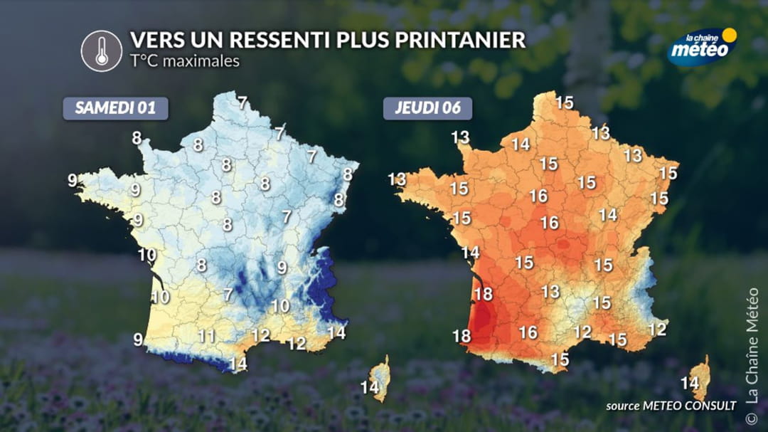
Thursday, temperatures should still go up a notch, including 15 in Paris, Lille or Strasbourg. It will be 16 in Orléans and Toulouse as well as 18 in Bordeaux and Biarritz. Thus, “several spring days are coming with a beautiful brightness and generalized sweetness”, announces the weather channel.
For Friday, March 7, a fairly sunny day is also expected, but the specialized site indicates that a “disturbance could still succeed in infiltrating by the Channel and the Atlantic”. This is what Météo-France confirms: “The start of the week should be rather cold and dry. Temperatures should go back during the week above seasonal norms. Possible return of more disturbed time at the end of the week”. Reliability remains limited to this deadline, however, to know exactly when the disturbance returns.