The drone has been used to monitor NATO’s eastern border.
Jari Strömberg,
Maria Stenroos
NATO’s large surveillance drone flew for the first time in Finland’s skies on Wednesday.
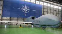
An unmanned aerial vehicle called Phoenix flew high above Finland patrolling NATO’s eastern border. The plane is operated by the Italian Air Force.
The RQ-4D or Phoenix is one of the largest and most modern drones. Its wingspan is almost 40 meters, i.e. the same as that of ordinary passenger planes. It can fly at an altitude of up to 18 kilometers.
NATO says it used a drone to monitor its eastern border after Russia invaded Ukraine. According to NATO, most of the missions have been in the Black Sea. A large remote-controlled drone collects intelligence, monitors and identifies.
When Finland joined NATO, at the same time Finnish airspace became part of NATO’s air surveillance. Since Finland is a new member, NATO now collects data from the air on Finland’s territory using various tools.
According to the Defense Forces, the flight was part of normal bilateral and multilateral cooperation was informed in spring.
According to the Defense Forces, flights will be conducted in Finnish airspace in the future as well, and flights will be made with different types of aircraft, both unmanned and manned. Their details cannot be disclosed for reasons of operational security.
Manned and unmanned surveillance flights
Aviation news portal Air mail says that so far at least US and Swedish manned surveillance flights have been observed over Finland. According to unconfirmed information, the French would also have performed surveillance tasks over Finland.
Recently, fighters from different NATO countries have been constantly visiting Finland to get to know the conditions and train.
According to Lentoposti, this is the first time that an unmanned aircraft has performed a visible surveillance flight over Finland.
Even the route of the plane could be followed in public Flightradar24 -tracking service, because the plane flew under the code Magma 10.
The plane’s route started from the Gulf of Finland, moved overland near Loviisa, continued its journey from between Kotka and Kouvola over Uti towards the northeast directly between Savonlinna and the eastern border of Finland to the height of Joensuu.
There the airplane turned to the northwest and continued its journey again in the direction of the border to the height of Nurmes and turned around near Kajaani. The return trip came exactly along the same route. The route was flown several times.
Correction September 14, 2023 at 8:18 a.m.: According to Lentoposti, it was the first time that an unmanned aircraft has made a visible surveillance flight over Finland. Originally, the story stated that it would have been the first time that a reconnaissance flight was made with visibly traceable identifiers.
Update 14.9. at 2:30 p.m.: Supplemented the beginning of the story with information published by NATO