Six Normandy and Ile-de-France departments are placed on orange snow-ice alert this Tuesday, January 9 as a winter episode affects France this week. Snow removal and road salting measures are underway while the A12 and A13 are temporarily closed.
The essential
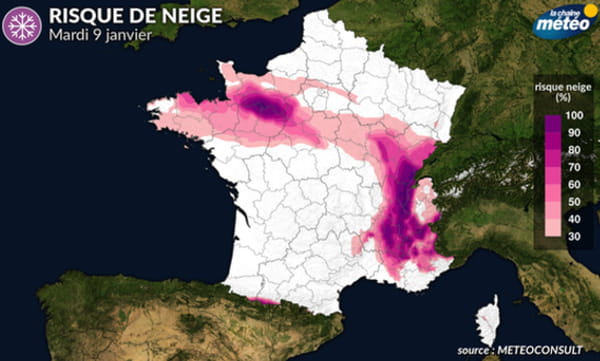
- Snow is falling in several regions of France this Tuesday, January 9. And six departments are placed on orange snow-ice alert by Météo France: Eure, Orne, Calvados, Manche, Yvelines and Essonne. The weather agency says snowfall amounts are “higher than expected.”
- Traffic is complicated by the centimeters that stick to the ground and the ice on several roads. The A12 and the A13 are “temporarily” closed in Ile-de-France but the police headquarters specifies that “measures to clear snow and salt the roads” are in progress.
- The peak of the French wave which affects France is expected this Tuesday, January 9. Temperatures are mainly in the negative and oscillate between -5°C and 0°C in the northern half. Only along the Mediterranean and Corsica maintain positive temperatures.
Live
08:21 – Up to 10 centimeters of snow expected
According to Météo France forecasts, “the snow will continue to fall for a good part of the day, but in increasingly smaller quantities”. On the ground, the quantity of powder should change little and will reach “a maximum of 8 cm, or even very locally 10 cm in Calvados”.
08:05 – Difficulties on the roads, but “traffic is being resolved” assures Beaune
Traffic difficulties have been observed on several roads in Normandy and Ile-de-France since yesterday evening. Traffic jams lasting several hours and accidents occurred during the night and early morning, particularly on the A12 and the A13. Faced with these difficulties caused by the few centimeters of snow, the Minister of Transport went “to the Île-de-France roads department to take stock of the progress with the agents mobilized all night and greet the teams” at 7 a.m., according to information from franceinfo. A little later, the minister declared on RMC that “traffic is in the process of reducing”, recalling that at the “beginning of the night, around 1,000 vehicles were blocked”.
07:57 – A sixth department on orange snow-ice alert
La Manche joined the five departments placed on orange snow-ice alert since dawn this Tuesday, January 9: Eure, Orne, Calvados, Yvelines and Essonne. “A snowy axis extends from the Paris region to Lower Normandy” and “the quantities of snow fallen are greater than expected” indicates Météo France in its latest report. The meteorological agency does not rule out a “temporal extension of vigilance”.
01/08/24 – 11:27 p.m. – Risk of snow in the South-West on Wednesday and Thursday!
END OF LIVE – If the center-east and Normandy are more concerned for the moment, La Chaîne Météo warns that the risk of snow will then concentrate on the south-west of the country, Wednesday and Thursday. The forecasts still need to be refined, but La Chaîne Météo estimates that the rain-snow episode should begin early Wednesday morning and gradually gain more consistency in the afternoon. On Thursday, several departments should wake up to a landscape covered in a white coat. Haute-Garonne, Aude, Ariège, Gers, Hautes-Pyrénées, Tarn and Tarn-et-Garonne seem to be for the moment the departments which should have the most chance of being affected by snow on the plains.
01/08/24 – 8:35 p.m. – Snow: what are the forecasts in the coming hours?
In its evening bulletin, La Chaîne Météo indicates that in the evening and tonight, snowfall described as “light to moderate” mainly concerns the Cotentin and the Normandy hills. One to three centimeters of snow are expected in places. Snowfall which should however ease during the morning of Tuesday. As for the thermometer, La Chaîne Météo mentions minimums of between -7°C and -3°C in the plains in the departments placed on “Extreme Cold” alert. Tuesday afternoon, no thaw to be expected between the Grand-Est and eastern Brittany. In addition, light snowfall will be expected in northern Brittany.
Learn more
The cold which is spreading throughout the territory for this week of January 8 comes straight from Scandinavia and central Europe, as stated The Weather Channel. This cold snap is part of a tense meteorological context in France while Pas-de-Calais and the North are slowly recovering from the last significant episodes of flooding the previous week. The two departments are still on orange alert for the risk of flooding.
This week, the cold will be intense in the east of the country. The Weather Channel has notably placed several departments in the north-east on alert for cold weather. In detail, these are Aisne, Ardennes, Aube, Marne and Haute-Marne, Meurthe-et-Moselle, Meuse, Moselle, Oise, Haut and Bas Rhin, Haute-Saône, Somme, Vosges and the Territoire de Belfort. Meteo France has also placed most of the eastern part of the country on yellow alert for severe cold and risk of snow and ice.
As for temperatures, these should remain in the negative for a large part of the week. From this Monday, January 8, the northern hemisphere of France is experiencing temperatures between 4°C, as in Brest, and -2°C, notably in Lille, Chaumont and even Rouen. The Weather Channel forecasts for this Monday January 8 “minimum temperatures between -4 and -2°C and maximums between -2 and 0°C this afternoon”. The cold peak is nevertheless expected this Tuesday, January 9. Météo France forecasts -5°C in the east in Strasbourg and in the Center in Aurillac. Only the Mediterranean coast and Corsica will be positive with 6°C in Marseille, 9°C in Nice and 10°C in Ajaccio.
The Weather Channel also predicts frosts “from Hauts-de-France to Normandy in the Grand Est”, which is confirmed Meteo France which announces frosts “widespread and severe in a northeast quarter, in places in the Center-Val de Loire or the southwest plains.” Snow is also expected during this week according to The Weather Channel. She explains that the meeting between cold air and humid air from the Mediterranean “is conducive to the risk of snow episodes in the coming days.”
Snow is expected with light falls from this Monday in the French massifs, from the Alps to the Pyrenees via the Jura and the Massif Central. In a special press release, the site specifies that “5 to 10 cm of snow are expected from 500 meters of altitude, up to 15 to 20 cm around 1000 meters by Monday”. If the snow forecast remains to be refined, La Chaîne Météo indicates that a white coat could also be deposited further north “From the Loire Valley to Normandy to Brittany via Perche”.