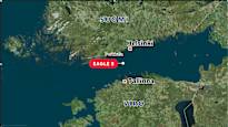
The Finnish authorities suspect that the oil tanker and its anchor have damaged the Estlink 2 electrical cable.
The tanker is suspected of belonging to Russia’s so-called shadow fleet.
We compiled the most important maps of its movements.
1. Tanker near Porkkala
Finnish Border Guard’s patrol ship Safety escorted the tanker in front of Porkkala on Wednesday Christmas Day in the early evening.
In the picture below, you can see how Turva was also patrolling very close to the tanker on Thursday afternoon. Vesselfinder-site according to the distance between the ships is about 500 meters.
2. Twirling on Christmas Day
The Eagle S ship, which left the port of Ust-Luga or Laukaansuu in Russia, was on its way to Egypt. It proceeded on a direct route in the Baltic Sea for the first time.
On Wednesday afternoon, however, it made a turn, Marine Traffic finds out –from the site.
The tanker made a U-turn at around 13:50 Finnish time and proceeded about half a kilometer backwards on its route. Then the ship hooked back to its old route at around 14:20.
The capsize occurred about an hour and a half after the ship had crossed the Estlink 2 cable.
The reason for the spin is not yet known.
The graphic below shows the tanker roll:
3. The ship was at the cable at the time of damage
The connection to the Estlink 2 cable was interrupted on Christmas Day at 12:26 Finnish time, according to the grid company Fingrid.
The maps on the Marinetraffic website show how the ship moved over the cable during the incident:
Currently, the tanker is in the possession of the Finnish authorities off Porkkalanniemi, about 15 kilometers from the mainland.
The police are conducting a preliminary investigation on board.
The map shows where the tanker is now.
