With the approach of the Belal weather system, which promises to be intense, Reunion will be placed on red cyclone alert from this Sunday, January 14 from 8 p.m. (local time, 5 p.m. in Paris), announced the prefect of this island French Indian Ocean. He called on residents to “dedicate the coming hours to doing nothing other than preparing for confinement”, in particular by ensuring “the place where we are going to shelter” and “the availability of our reserves”.
From this Sunday evening until Tuesday morning, “each and everyone must confine themselves to a safe place”, asked prefect Jérôme Filippini during a press conference. The president of the region Huguette Bello called on “the people of Reunion to exercise the greatest caution”, in a message on the social network face,” she added.
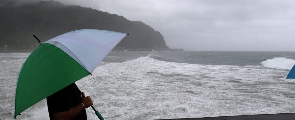
The authorities fear that Belal, which is currently a “strong tropical storm” located some 280 kilometers northwest of Reunion, will become an “intense tropical cyclone” this Monday, January 15, as it passes over the island or beyond. immediate proximity. Its winds could be “devastating”, according to Météo France, with the agency referring to a cyclone “which could mark the history” of Reunion Island. The island had not been hit by an intense cyclone for ten years and the passage of Bejisa, in the first days of 2014.
“What is happening on Reunion Island is a phenomenon which is undoubtedly even more intense than what we could evoke yesterday when we gave references to 10 years, 20 years,” warned the prefect, rather evoking Jenny in 1962. That tells you how serious it is,” he added.
“Destructive and devastating winds”
According to Météo France, “cyclone Belal will be intense with winds that could exceed 200 km/h on the coast and 250 km/h or more” in the heights of the island. “Destructive and devastating winds which can cause great damage,” estimated Sébastien Langlade, head of forecasting at Météo France Réunion. Given the expected precipitation, “certain rivers, certain gullies, will undoubtedly exceed the red threshold tomorrow Monday. These are thresholds which have references to 30 years or 100 years. This means that we are going to have an event major,” insisted the prefect.
Roland-Garros international airport, in the commune of Sainte-Marie (north), announced its closure at 4 p.m. local time (1 p.m. in Paris) and all public transport networks will stop at 6 p.m. (3 p.m. in Paris), until further notice. The prefecture has already advised against taking the coastal road, “except in cases of emergency”.
Six living centers have been set up for patients requiring equipment for their care, in addition to the 142 accommodation centers deployed throughout the region to accommodate people in precarious circumstances or those living on the banks of ravines or rivers in case of flooding, according to the authorities. The spectacle of the swell which began to break on the coasts attracted many onlookers late Sunday morning. The prefect called on the population “not to get too close to the sea”. “Don’t start a photo competition!”, he warned.