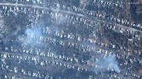
Space technology company Maxar Technologies has released new satellite images of Bahmut, showing the devastation of ten months of fighting in the city.
Recent satellite images of Bahmut show, among other things, burning and destroyed residential areas, bridges, roads and industrial buildings. According to Maxar, the photos were taken on Monday, so there has probably been more damage since then.
Wagner, the Russian mercenary army fighting in Bahmut, has said that it controls all the areas east of the Bahmut River, which runs through the city. The Institute for the Study of War (ISW), a think tank that closely follows the war in Ukraine, said in its Friday situation review that it does not believe that Wagner is currently capable of attempting to cross the river.
Instead, the mercenary army, which suffered heavy losses, is now believed to be waiting for regular Russian troops to arrive in the area, so that it could itself step into the rear of the fighting.
There have been heavy battles for the control of the city of Bahmut since last May. Several parties have assessed that Bahmut does not have a great strategic importance in terms of the war. President of Ukraine Volodymyr Zelenskyi however, claimed in an interview with CNN on Tuesday that Russia would have an “open road” to other central cities in eastern Ukraine if Bahmut were lost.
– We understand that after Bahmut they could go further. They could go to Kramatorsk, Slovyansk. The road would be open to the Russians after Bahmut.
At the same time, Zelenskyi assured that the military leadership of Ukraine is unanimous on continuing the defense of the city.
