Published: Less than 20 min ago
Kristianstad is known for its expanses, its rich bird life and the nature reserve Vattenriket.
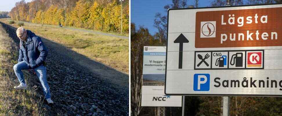
But Kristianstad is also Sweden’s lowest-lying city, where the lowest point is 2.32 meters below sea level – which means that if the water levels rise.
Now the city is preparing for future climate changes with a new embankment 4.5 meters above sea level. With upgraded and newly built protective dikes along Helge å and Hammarsjön, Kristianstad will be protected from flooding even after the turn of the next century. Should the dike break, large parts of the city would be under water.
Kristianstad prepares for the effects of future climate change.
New and higher dikes are now being built to protect the city against floods.
– We are doing this to protect the city against high tides and future sea level rises, says Karl Erik Svensson, project manager for the dike construction.
This was close to happening in 2002 when a high tide of 2.15 meters meant that the Hammarslund dam was at risk of bursting.
– In ten years, this cycle path we are standing on will no longer exist. Then the water has risen so much, says Karl Erik Svensson, looking out over the lake’s edge towards the railway track that borders the old wall that is now to be raised.
Kristianstad municipality receives the maximum city grant for the construction of Pynten’s pump station in Hammarslund. More than half of the construction cost is covered by a grant of SEK 160 million.
The first dike was two meters above sea level and was built in 1860. The next dike was completed in 2003 and was three meters above sea level. Now the 1.4 kilometer long embankment must be raised by another 1.5 meters and a new pumping station built inside the embankment. A work that should be completed in 2026. With it, they hope to be able to meet the increased water levels that climate scientists warn about.
– We take the IPCC report on elevated water levels seriously and have adapted accordingly. According to calculations from SMHI, we have taken height for a water rise of one meter until the year 2100. This dike is calculated to prevent the water from entering the city for a long time, says Karl Erik Svensson, who goes by the name Vall-Kalle in the area .
The fact that things have turned out the way they have in Kristianstad and the surrounding area, with floods in season and out of season, is to some extent the fault of the human factor, he states.
– By exploiting the lands, we have destroyed nature’s own opportunities to take care of the water. In 1860, the city needed more farmland and dug out large areas, and after that the floods have come and gone, says Karl Erik Svensson.
Add a sea level rise to these annual water flows and you get some complicated math to decide on.
In the department for climate adaptation at the Norwegian Geotechnical Institute, they are well aware of the problems surrounding Hanö Bay, where Kristianstad is located.
– Kristianstad is unique in that way because the threat to the city comes from two directions. On the one hand, climate change will cause a rise in sea level and, in addition, there will be floods in Helge å. This combination will be quite difficult in the future, predicts civil engineer Per Danielsson, national coordinator for beach erosion at the Norwegian Geotechnical Institute.
Since the 1980s, water levels have risen by 20 centimeters around Lake Hammarsjön, and if it rains a lot in Småland, there is cause for concern. At the last high water in February 2020, the water rose by two meters. This led to the closure of the cycle path in Tivoli Park and temporary reinforcements had to be made on the Hedentorpsvallen, where water seeped out into the street.
– If there is heavy rainfall during autumn and winter, Helge å quickly fills up. But we have good control all the way up to Agunnaryd. The water level and water flow are monitored through a forecasting system called “flood watch”. Therefore, a high tide in Kristianstad never comes as a surprise, but we have at least ten days’ notice to react to the water flows, says Karl Erik Svensson.
Kristianstad’s municipality has so far received a total of just under 117 million in state grants for its embankment construction. The contribution to Pynten’s pumping station is the largest single contribution that has been paid out in Sweden. The final bill is estimated to be approximately SEK 1.6 billion
Kristianstad resident Mikael Lövström has witnessed several serious floods in the city and supports the city’s attempts to block Olle by raising the dikes towards the city.
– It’s not the first dam to be built and they have to do something. Flooding has become commonplace in Kristianstad. It is worrying, says Mikael Lövström and continues:
– You think about it every time there is a downpour and you are worried about how your children and grandchildren will suffer in the future. Then one can wonder what King Christian IV was thinking when he built the city on an old lake bed in the 17th century.
Facts
Background
arrow The Norwegian Geotechnical Institute, SGI, and the Swedish Agency for Community Protection and Preparedness, MSB, were tasked by the government in 2019 with identifying areas where there is a risk of landslides, landslides, erosion and flooding that are climate-related.
arrow The focus has been on identifying larger cross-regional risk areas where the risks are complex and require cooperation in order to be prevented, this in order to get a national overview of the situation.
arrow In the report submitted in 2021, ten areas in Sweden where such climate-related risks are particularly high are ranked. The Skåne and Halland coast is an identified risk area.
arrow At the beginning of 2021, Kristianstad municipality adopted a plan for a complete dike system that should be able to protect Kristianstad against flooding for more than 100 years to come.
Read more