A new report warns of a scourge which affects more than half of homes in France and continues to spread across the country. Some departments are even more affected…
A family with two children forced to live in an almost uninhabitable house, tossed between insurance companies, without alternative housing and waiting for expert opinions and decisions that do not come. She will have to wait seven years between the start of the problems and a possible return to normal life. It is with this real-life example that begins a report on the RGA, published at the beginning of October.
RGA is the “shrinkage-swelling of clays”. A phenomenon which is spreading more and more in France and which already affects almost half of the territory, more than half of individual houses. RGA is the result of increasingly common and intense droughts which, followed by heavy rains, make soils unstable in many departments. The most visible symptom: the cracks which are multiplying in many constructions, particularly in houses.
According to the report, this phenomenon “is increasing and is increasingly costly, causing disasters in the France of small owners.” It actually concerns 48% of the metropolitan territory, “especially individual houses, and rarely buildings, whose foundations are deeper and the structure more rigid”. “In 2022, of the 20.3 million individual houses in France, 11.1 million (or 54%) present a risk of clay shrinkage-swelling,” we can read.
The report indicates that the “RGA risk” is “unevenly distributed across the territory”. Several statistics have been established to evaluate it in the municipalities and departments. In 2021, exposure to RGA was notably calculated by the Statistical Data and Studies Service (SDES) to feed the indicators of the National Observatory of Natural Risks (ONRN). Here is the share of housing affected by a “medium or high” RGA risk by department (in %). In certain areas, almost all housing is affected:
| More than 50% of housing affected | Less than 50% of housing affected | ||
|---|---|---|---|
| Val de Marne | 99.6% | Pyrénées-Atlantiques | 48.8% |
| Haute-Garonne | 98.2% | Vendee | 46.2% |
| Vaucluse | 98.2% | Bas-Rhin | 42.2% |
| Lot-et-Garonne | 98.2% | Haute-Loire | 40.2% |
| Seine-Saint-Denis | 98.0% | Haut-Rhin | 40.0% |
| Tarn-et-Garonne | 96.4% | Orne | 39.3% |
| Alpes-Maritimes | 94.7% | Haute-Marne | 37.1% |
| Aude | 94.3% | Yonne | 36.7% |
| Essonne | 93.7% | Eure | 36.7% |
| Gers | 93.2% | Pas-de-Calais | 36.1% |
| Alpes de Haute Provence | 93.0% | Corrèze | 35.5% |
| Bouches-du-Rhône | 92.9% | Drome | 33.8% |
| Loiret | 92.0% | Aisne | 33.2% |
| Seine et Marne | 91.7% | Eastern Pyrenees | 32.7% |
| Indre-et-Loire | 91.3% | Dawn | 32.7% |
| Tarn | 90.4% | Aveyron | 32.6% |
| Allier | 89.9% | Calvados | 31.2% |
| Gard | 89.6% | Ain | 31.0% |
| Meurthe-et-Moselle | 87.0% | High mountains | 30.7% |
| Var | 87.0% | Marl | 27.7% |
| Indre | 86.3% | Rhone | 26.3% |
| Golden Coast | 85.6% | Cantal | 26.2% |
| Hérault | 85.0% | Dig | 24.5% |
| Gironde | 83.9% | Ardennes | 23.8% |
| Dear | 83.4% | Loire | 21.5% |
| Jura | 81.9% | Haute-Vienne | 19.5% |
| Vienna | 81.4% | Loire Atlantique | 18.9% |
| Charente | 81.1% | Seine-Maritime | 18.6% |
| Moselle | 77.4% | Savoy | 18.4% |
| Loir-et-Cher | 77.1% | Sum | 17.6% |
| Ariège | 77.0% | Landes | 16.7% |
| Hautes-Pyrénées | 75.2% | Haute-Savoie | 15.4% |
| Nièvre | 73.2% | Lozere | 13.6% |
| Sarthe | 72.5% | Sleeve | 12.6% |
| Batch | 72.4% | Vosges | 12.2% |
| Saône-et-Loire | 71.9% | Morbihan | 9.0% |
| Hauts-de-Seine | 71.2% | Isère | 6.3% |
| Eure-et-Loir | 70.5% | Côtes-d’Armor | 5.4% |
| Yvelines | 67.6% | Ille-et-Vilaine | 5.2% |
| Val d’Oise | 67.0% | Mayenne | 3.3% |
| Maine-et-Loire | 64.5% | Upper Corsica | 2.6% |
| Haute-Saône | 62.7% | South Corsica | 0.6% |
| Dordogne | 62.7% | Paris | 0.0% |
| Oise | 61.4% | Finistère | 0.0% |
| Territory of Belfort | 60.2% | ||
| North | 59.9% | ||
| Doubs | 58.4% | ||
| Meuse | 57.7% | ||
| Charente Maritime | 57.1% | ||
| Puy de Dome | 56.5% | ||
| Two Sevres | 53.6% | ||
| Ardeche | 53.4% | ||
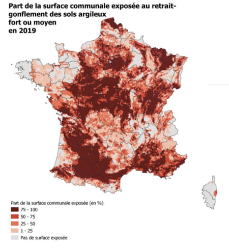
The Geological and Mining Research Bureau (BRGM) has produced a finer map, illustrating the share of the municipal surface exposed to the RGA in 2019 with scales ranging from 0% of exposed surface to an area between 75 and 100%:
The parliamentary report also cites Haute-Garonne, Gironde and Bouches-du-Rhône among the most affected departments. Already very populated areas (Toulouse, Bordeaux, Marseille) which are added to Île-de-France, which is not spared.
Data established by insurers finally complete these indicators, such as those from France Assureurs, the federation of insurance companies, which published another report on the subject in 2022. Over the period 2020-2050, the cost of the RGA is estimated at 43 billion euros, triple compared to 1989-2019.

