Once again, the Mars Express probe reveals magnificent images of the Martian landscape, the reading of which makes it possible to reconstruct a volcanic environment where water flowed freely.
You will also be interested
[EN VIDÉO] Mars Express: 15 years of observing Mars in high resolution After traveling 500 million kilometers to reach Mars, the Mars Express probe has traveled twice as many since its installation in orbit more than 15 years ago. To celebrate the anniversary of its high-resolution HRSC camera, ESA and DLR are taking us on a tour of the Red Planet through its piercing eyes. The landscapes are breathtaking.
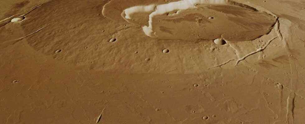
The probe Mars Expresswhich orbits around the red planet since 2003, still unveils new breathtaking images. In a relatively small area, the ESA probe managed to capture a compendium of geological structures: volcanocanyons, lava flows washtectonic faults and an amazing impact crater that teaches us a little more about the history of Mars and the presence of water liquid on its surface.
A volcano emerging from a sea of lava
The images reveal to us with incredible precision the morphology of a small volcano, Jovis Tholuslocated near titanic Olympus Mons. The caldera, whose summit rises 1 km above the plain, is clearly visible. The volcanic edifice is largely amputated by the presence of a large crater, the bottom of which is particularly smooth, just like the surrounding plain.
This morphology suggests that the volcano rose above a sea of lava that covered the entire area. The canyons streaking the surface with a north-south orientation also seem erased. We only see them reappear clearly in the northeast corner of the images. These are actually faults of tectonic origin, prior to the eruption of the volcano, and now filled with lava from different eruptions. These faults testify to ancient tectonic activity of the planet and its now extinct geodynamics.
To the east of Jovis Tholus, the topographic images reveal a bulge, significant of the presence at this location of a second volcano, much less developed. The summit of the bulge is marked by a large crack, very clear, from which escape traces of lava flows. This morphology is reminiscent of an activity eruptive characterized by a magma very fluid, escaping from a crack without leading to the creation of a volcanic edifice, a bit like what can be observed on Earth in Iceland.
A meteorite impact in waterlogged ground
A little further, to the northwest, a crater 30 km in diameter deeply marks the surface of the Martian soil. The ejecta corona that surrounds it tells us that this is an impact crater, caused by the fall of a meteorite or a comet. The particular morphology of the ejecta suggests that the meteor has struck ground that is waterlogged, in liquid or ice form.
This is not the only witness to the past presence of water in this region. The reported data by Mars Express indeed show traces typical of a strongly channeled environment, particularly in the northwest corner of the image. From the great fault that cuts the ground at this place connects a whole network of channels. You can even see the presence of terraces and meander bars. The similarity with terrestrial river landscapes is striking.
These images make us imagine large quantities of water flowing northwest via the grand canyon created by an ancient fault. This liquid water would result from the melting of the ice of the basement under the action of the heating of the intense volcanic activity having dominated the region.
In a very limited area, Mars Express therefore provides us with a picture of the past environment of Mars, where seas of lava and torrents of liquid water.
Interested in what you just read?