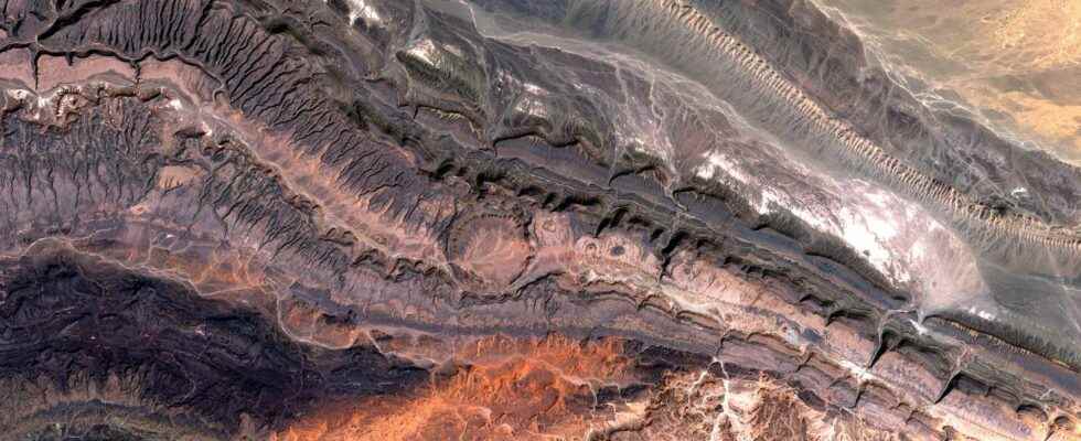
Satellite images, which are increasingly precise and spectacular, often reveal astonishing landscapes that are generally invisible from the ground. In this image, it is the chain of the Anti-Atlas which reveals its magnificent colors with, as a bonus, the crater of Ouarkziz.
You may also be interested
[EN VIDÉO] Cnes satellites at the service of global oceanography Since 1992, satellites have provided precise monitoring of the seas. Having become essential to oceanographers, they allow daily monitoring of changes in this complex ecosystem. The Cnes (National Center for Space Studies) tells us more during this video.
This astonishing image taken on March 9 by the Sentinel-2A satellite of the European Copernicus program reveals a magnificent combination of geological structures. The long line that stretches from left to right is none other than a very old mountain range, the Anti-Atlas, which crosses the south-west of Morocco and Algeria. As its name suggests, it is part of the Atlas, an enormous massif which marks the landscape of North Africa.
The remains of a gigantic mountain range
In the area photographed by the satellite, the Anti-Atlas marks the border with the Sahara Desert in western Algeria. This mountain range, some peaks of which reach more than 3,000 meters, is 600 km long. It was formed about 300 million years ago during a major episode of continental collision called orogeny Alleghenian: the African plate then meets the Laurussia plate to form the supercontinent Pangea. Scientists believe that the Anti-Atlas was originally supposed to rise higher than the Himalayas. Over millions of years, erosion will however have had time to severely plane the reliefs.
The rocks that make up the Anti-Atlas are therefore very old and the relief is particularly rugged. This massif is well known to paleontologists since several great discoveries of dinosaur bones have been made there. But the satellite image reveals another treasure of this mountain range.
A very well preserved meteorite crater
In the center of the image, we clearly distinguish a perfect circle. This is the meteorite crater of Ouarkziz. With a diameter of 3.5 km, it was formed by the impact of a meteor about 70 million years ago. Despite the particularly arid climate of the region, we can see that the interior of the crater is marked by traces of channels (tree-like shapes that extend from left to right). The occasional flow of rivers certainly allowed the sedimentary filling of the crater.
This crater is one of the geological structures clearly visible from space and in particular from theISSallowing astronauts to identify with precision.
Interested in what you just read?