The National Institute of Geographic and Forest Information is currently working on a high definition topographic map of France. The map will consist of a cloud of points obtained with Lidar, and some parts are already freely accessible.
You will also be interested
[EN VIDÉO] France seen from space by Thomas Pesquet Discover France photographed from space by Thomas Pesquet during his six months on the International Space Station. A beautiful walk to see France differently, at an altitude of 400 kilometers.
In a few years, it will be possible to visualize all of France in three dimensions. The National Institute for Geographic and Forest Information (IGN) has embarked on the titanic project of scanning the entire country thanks to the lidar and thus create a topographic model giant.
The project, simply called Lidar HD, should be spread over five years and cost around 60 million euros. The data is collected using aircraft carrying Lidar sensors that fly over the territory. IGN has two planes and uses service providers for the rest of the data, for an estimated total of 7,000 flight hours. The institute aims to collect an average of 10 points per square meter throughout France, i.e. a total of three petabytes of data.
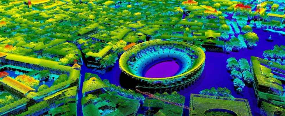
Some areas already available online
Once processed and validated, the data is available to the general public on the IGN website. It will be necessary to use specialized software, such as CloudCompare, to view the contents of these files. The institute plans to finish this work by the end of 2025 and has published a map of his advancement.
IGN has already put raw data from several areas online, including the cities of Montpellier and Nîmes. These files contain only the cloud points without further information. However, the IGN intends to classify each point by identifying what it corresponds to (building, soil, vegetation, etc.) and create digital models which will be available later. These data should be used for prevention of natural risks, knowledge of forest resources, management of agricultural plots, land use planning, preservation of biodiversityinternal security, energy transition… »
Interested in what you just read?