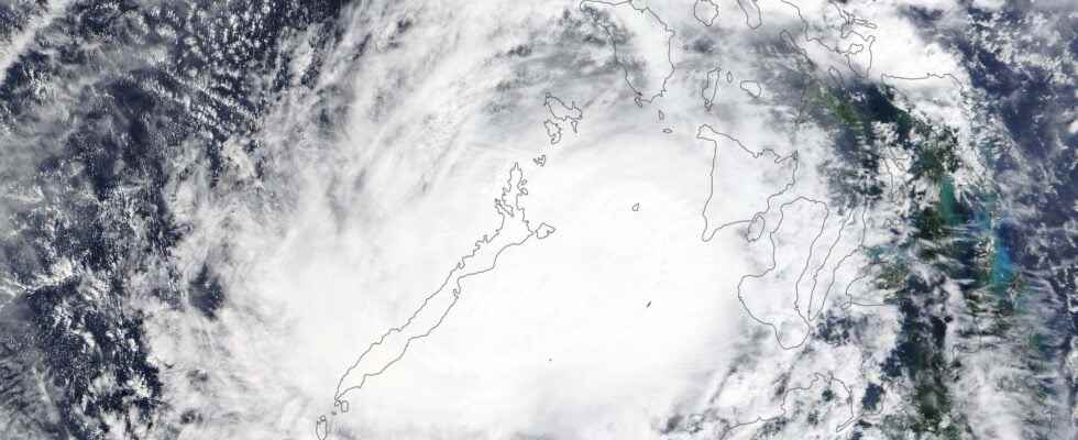
Super-Typhoon Rai ravaged the Philippines between December 14 and 18, with winds exceeding 250 km / h and massive submersion of the coast. Warming Pacific waters and rising sea levels could lead to much more intense cyclonic phenomena, like Rai, by 2050.
You will also be interested
[EN VIDÉO] Supertyphon Haiyan: at the heart of the disaster On November 8, 2013, Typhoon Haiyan, with winds of 380 km / h, ravaged part of the Philippines, killing several thousand people. Exceptional in its power, this storm must be studied to better understand it, as this documentary explains.
Typhoon category 5 (maximum) claimed the lives of around 400 people, but thousands more are still missing. The islands of Bohol, Siargao, Dinagat and Mindanao were the most affected by the disaster. This is the 9e typhoon season cyclonic 2021, out of a total number of 10 to 20 listed on average each year across the country. In addition to its violence, and the fact that it weakened to reactivate several times in the space of a few days, Typhoon Rai occurred quite late in the season: although typhoons can form almost anytime of the year off the Philippines, the majority occur from mid-June to mid-September.
If the force of the winds is impressive, it is the precipitation that generally causes the most damage and casualties.
The peak of typhoon activity, in number and intensity, is usually in August. This is only the third Category 5 typhoon to form in the South China Sea, with the other two dating from 2014 (Rammasun) and 1954 (Pamela).
If the strength of winds impresses, it is the precipitation which generally causes the most damage and casualties, and this for all cyclones of the world (typhoons and hurricanes). The meteorologists estimate that 30% of precipitation annuals in the Philippines came from typhoons. Cyclonic phenomena are responsible for a third of the total number of victims of climatic disasters in the world for 50 years according to the World Meteorological Organization.
Heat, humidity, sea level: the ingredients of typhoons
In recent years, a probable link has been demonstrated between an increase in ocean surface temperatures and stronger cyclonic phenomena. Even if all the secrets have not been unlocked as to the link between climate change and the intensity of cyclones, the latest studies agree on the same projections: warmer water gives more heat.energy typhoons to intensify, but not necessarily to multiply. We are therefore heading towards more intense cyclonic phenomena (category 4 and 5), but not necessarily more numerous.
Some climatologists even think that there could be less cyclonic phenomena in the future, but much more intense. Associated with an increasing human population and more constructions on the coasts, the impact of more intense typhoons and hurricanes looks devastating in the future. More heat in the atmosphere also leads to more intense precipitation and these two ingredients weather report – heat and humidity – in turn feed cyclones, providing them with the fuel they need to intensify. And by intensifying, cyclones generate even more precipitation, a veritable vicious circle!
But the heat of the oceans and the humidity of the atmosphere are not the only worrying factors to consider. Indeed, the rise in sea level is the most determining parameter in the destructive capacity of typhoons. A higher water level inevitably leads to a higher great coastal submersion, a consequence much more serious than that caused by the force of the winds.
Other climatic factors, such as the circulation of atmospheric currents, also influence the development of cyclonic phenomena. The consequences of certain other climatic phenomena, which influence the development of these cyclones, are even contradictory with the current conclusions on the intensity of the cyclones. This is why it is very difficult to carry out forecasts precise and reliable on the evolution and the dangerousness of these phenomena in the future.
Much more severe typhoons and hurricanes from 2050
Over the past 30 years, marked by an acceleration in global warming, climatologists have nevertheless recorded an increase in the average intensity of cyclones: according to Climate Signals, cyclonic phenomena are more powerful by 2 km / h on average than 30 years ago. Likewise, once formed, cyclonic phenomena reach category 3 more quickly than they did 25 years ago: 9 hours earlier on average, and even a day earlier for hurricanes off the coast of North America. North.
According to Professor Kerry Manuel of the University of Massachusetts Institute of Technology (MIT, USA), the intensification of cyclonic phenomena, linked to climate change, will not be really visible until 2050. The super typhoons that we are currently experiencing would be only weak clues, almost anecdotal on the scale of the weather, compared to projections over the next 30 years. If climate change seems irreversible until 2050, it is necessary to develop means of adaptation which involve a radical change in the urbanization of coastal areas.
A few days ago, China rightly announced a research group on typhoons in Asia and the Pacific (Asia Pacific Typhoon Collaborative Research Center) in Shanghai, in order to better anticipate future typhoons and their consequences.
Interested in what you just read?
.
fs11
