
Most departments thought they were seeing the start of summer, but the sunny days are still delayed. When will the sun return?
Weather-wise, the weeks follow one another and are similar. While some thought that the month of June would rhyme with sunshine and blue skies, it seems that the weather decided otherwise. The next few days still look bleak in more than three quarters of the country. In the north as in the south, the sky should be particularly cloudy depending on The Weather Channel and temperatures will get dangerously close to those of October.
The last week of May is influenced by cold drop. Over a major part of the country, the disturbance that arrived earlier continues to cause heavy downpours, particularly in the central-east and south-east departments, which are the most affected. The few clearings in the middle of the week definitely fail to make a lasting impression beyond the south of France. Indeed, around the Mediterranean, the heat is rising, up to 28°C in Perpignan this week and between 23 and 25°C for the rest of the departments in the south of the country.
In the departments further north, on the other hand, it is cool all week, with temperatures that fail to exceed 20°C. A cold trend which is due to the numerous showers and stormy episodes which affect the Paris basin and the surrounding regions.
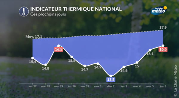
The first weekend of June is also likely to be cool and unstable due to the retreat of the Azores anticyclone and the strengthening of the mistral and the tramontane for the cities around the Mediterranean. Residents of the Provence-Alpes-Côte d’Azur region will have to bring out their umbrellas after a week where they were spared from bad weather. Throughout the country, gray should dominate blue. In terms of temperatures, we will be well below seasonal norms, we expect between 7 and 14°C in the morning and between 16 and 22°C in the afternoon from north to south, temperatures that The Weather Channel compare with those of “the beginning of October”.
We will have to wait two to three weeks to see the weather improve, because even if reliability is very low, meteorologists are already predicting a risk of stormy deterioration spread over at least the first half of June. These violent storms are still expected on the usual axis (from the northeast to the southwest). Only the south-east could benefit from dry weather, closer to a usual month of June, with an increase of 0.5 to 1.5°C compared to seasonal norms. Elsewhere, heat and showers will allow the humidity to increase, it risks being heavy over a good part of the country. Temperatures will slowly rise throughout the month of June but it no longer seems to be considered the hottest month of the year.
Clearly, France should be cut in two, between the north and the south, for this month of June, but it is not impossible that the southwest quarter joins the northern half, leaving the Mediterranean basin to be the the only part of the territory to benefit from the sun. It is therefore a risky month of June looming on the horizon, and which risks being disappointing, particularly for first-time vacationers and festival-goers.