All red alerts were lifted in the north-west of France on Thursday morning. Storm Ciaran then hit southern England and the Channel Islands.
Storm Ciaran continues its course in Europe. Falling trees caused by violent gusts are the cause of most fatal accidents. According to the latest report, a 5-year-old child and a 64-year-old woman died in Belgium, another in the center of Madrid, a truck driver and a man who fell from his balcony in France, a forty-year-old in Germany and one dead in the The Netherlands.
In Italy, where heavy rains caused rivers to overflow and caused flooding, three people died in Tuscany.
In the Flemish city of Ghent, a five-year-old child playing outside was injured by falling branches and died in hospital a few hours later, according to the local prosecutor’s office.
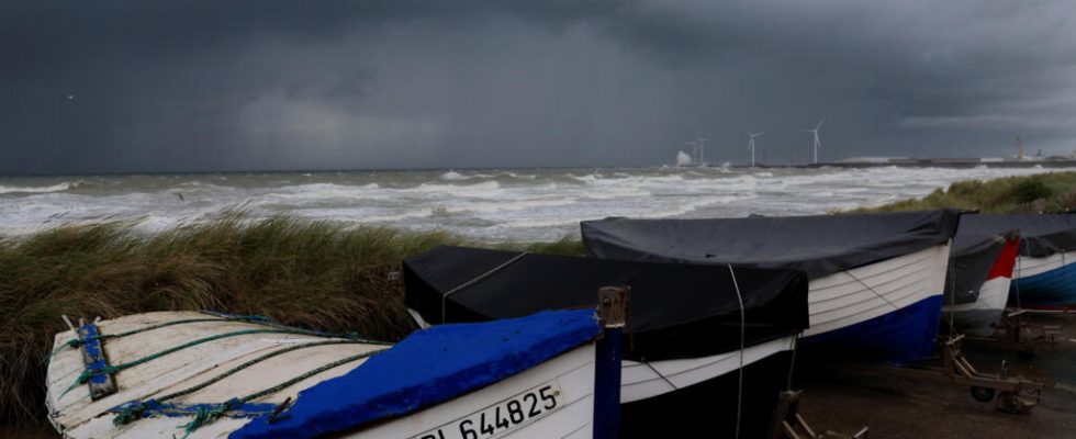
In France, during the night, winds approached 200 km/h in Finistère, in the west, and led to numerous power cuts: 1.2 million homes were without electricity this Thursday morning, including 780,000 in Brittany, according to Enedis, because of “ damage to the public electricity distribution network “.
All red alerts were lifted in the north-west of France at 9:00 a.m. UT this Thursday. There are only five departments on orange alert this morning. Red vigilance was lifted in Finistère at 6:00 a.m. UT then in Côtes-d’Armor an hour later.
While storm Ciaran continues its route towards the Channel and England, five other departments have now come out of orange wind vigilance: Finistère, Morbihan, Côtes-d’Armor, Ille-et-Vilaine and Orne, specifies Météo-France .
These orange alerts relate to risks linked to wind, waves-submersion or rain, depending on the department. The lull gradually takes shape, reaching Cotentin during the morning, then Normandy around midday, and finally Hauts-de-France in the evening. », affirmed Météo-France this morning.
“ The wind gusts are exceptional in Brittany and many absolute records are broken » locally, noted Météo-France on during the night, with 193 km/h in Plougonvelin, where Pointe Saint-Mathieu is located, 171 km/h in Lanvéoc, on the Crozon peninsula, or even 156 km/h in Brest.
Severe disruption in southern England
Strong winds and heavy rain brought by Storm Ciaran are causing significant disruption in the south of England this Thursday, with the suspension of all maritime connections from the port of Dover and hundreds of school closures. On the Channel Island of Jersey, placed on red alert, winds reached up to 160 km/h, forcing, according to local police, 35 people to be housed in hotels due to damage to their homes.
All schools and government buildings in Jersey are closed and authorities are recommending residents stay at home. At Jersey, Guernsey and Alderney airports, all flights have been canceled. “ All sailings are currently suspended from the Port of Dover », Also announced Thursday on X infrastructure. Winds of up to 100/110 km/h are expected in the morning, and up to 100 km/h in the afternoon, according to the weather report on the government website.
Due to adverse weather from Storm Ciaran, all sailings are currently suspended from the Port of Dover. Passengers should follow @PoD_travelnews and check with their chosen ferry operator for updates throughout the day.
— Port of Dover Travel (@PoD_travelnews) November 2, 2023
In Cornwall, in the southwest of England, placed on orange alert for violent winds, more than 8,500 homes are without electricity, according to the local authority. Flooding is also expected in 54 locations, mainly on the south coast of England, according to the Environment Agency.
The role of climate change in Storm Cairan
The first question that comes to mind: Did climate change play a role in this fast-moving storm? At present, scientists believe that we cannot establish a link between global warming and the formation of these storms like Ciaran. There are too many uncertainties and the measured effects potentially cancel each other out.
Among the factors in the formation of these storms, certain processes linked to energy exchanges, for example, strengthen, while others weaken, such as north-south temperature contrasts. We also do not see an increase in the frequency of these storms.
Despite everything, the impacts of these storms are greater, in particular because of the rains or winds that accompany them because our vulnerability is greater due to global warming.
Two examples: sea level is much higher than in the 20th century, marine flooding waves are therefore also higher and more dangerous. Then, summer now lasts longer: the trees have therefore not yet lost their leaves in November. This means more wind resistance. Then since it has rained in recent weeks, their feet are soaked and are therefore more likely to fall.
Read alsoFrance is preparing for the passage of storm Ciaran from this Wednesday evening
Roads closed and traffic prohibited
“ I didn’t sleep much, last night it was violent, I had never seen that. There are fallen trees everywhere. I’m going to go assess the damage in the town, the firefighters have already told me about a very damaged shed », told AFP Yves Robin, mayor of Porspoder in Finistère, near Brest this morning.
The fall of trees, branches and electrical and telephone lines led the Finistère prefecture to ban traffic on the entire road network in the department yesterday, with the exception of emergency and intervention vehicles. In Morbihan, as in Côtes-d’Armor and Manche, it is recommended not to use your vehicle, access to forests is prohibited and it is not recommended to go to the coast.
Emmanuel Macron joined the numerous messages from the authorities on Wednesday evening urging vigilance in the face of this climatic event. “ Don’t take any risks. Stay at home and check on your isolated loved ones “, he wrote on social networks. Almost everywhere on the coast, calls for caution, particularly for walkers and boaters, have increased.
(With AFP)