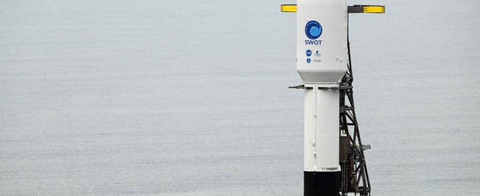
While Europe mourns the failure of the first commercial flight of its new small Vega-C rocket, the debris of which, with two satellites on board, scattered in the Atlantic two minutes after takeoff from Kourou (Guyana) at the end of December , in the United States, SpaceX continues to reap records. The company founded by Elon Musk has just completed the year 2022 with 60 successful launches and is aiming for a hundred take-offs for 2023 in order to complete its Starlink “cyber-constellation” in particular. With more than one rocket fired per week, SpaceX is reviving the splendor of Star Wars in the 1970s and 1980s. But the failure of Vega also reminds the entire industry of its unpredictability and will penalize Europeans for a long time, who find themselves without autonomous launchers following the delays accumulated on Ariane 6 and the impossibility of using Russian Soyuz rockets. It is also because of this blockage that the National Center for Space Studies (Cnes) and NASA had chosen to call on SpaceX (a service billed at 110 million dollars!) to place the revolutionary altimetry satellite Swot ( Surface Water and Ocean Topography), built by the Franco-Italian company Thales Alenia Space (TAS) and the American Jet Propulsion Laboratory (JPL), which must map the surface waters of the planet with unprecedented precision.
Previously, the satellite weighing more than two tons was assembled in Cannes (Alpes-Maritimes) and required fourteen months of meticulous work at TAS and its partners. With a budget of 1.2 billion dollars, the Swot mission must contractually last forty-two months, but “its instruments are planned to operate for at least five years”, assures Thierry Lafon, the mission’s project manager at Cnes. Present, as part of the European delegation, at the end of December at the American base in Vandenberg (California) for take-off, the French scientist was able to closely observe the Falcon 9 rocket used to propel Swot. This was the 6th take-off of this reusable SpaceX launcher. And if the operation was finally postponed by twenty-four hours, the fault of the presence of water detected on one of the engines, in the corridors of Vandenberg, the engineers of the American firm urged their counterparts from NASA to give the green light, just to quickly recover their precious baby to ensure future launches, the list of which is growing every week.
“A revolution in the field of hydrology”
Moreover, in the days preceding the launch, you had to see this ballet organized to the minute where SpaceX rents part of the Vandenberg space base. This US Army historic site, one of the largest in the country, located a three-hour drive north of Los Angeles, borders the Pacific Ocean. A hilly corner of California known for its farms and vineyards but from where US forces have quietly fired more than 2,000 rockets and missiles since 1958. Highly secure, the base nevertheless opened its doors to SpaceX, which has installed a gigantic hangar right next to the SLC-4, its official launch pad. This is where Thales engineers and their American colleagues integrated Swot into the fairing of the launcher. The first stage of the rocket, blackened by its previous round trips in space, also revealed the logo of the firm in a “faded washed” effect. Subtle marketing cleanup.
Nevertheless, the spectacle of the takeoff of the Falcon 9 is breathtaking. In the cool Californian night, the rocket tore itself from the ground at 3:36 a.m. in an impressive halo of light and a deafening din. Rising like a ball of fire to end up like a shooting star, the launcher finally returns, after propelling its satellite, to land 350 meters from its starting point on a small heliport whose floor, charred by previous launches, looks like a carpet of calcified dust.
After a few hours of stress for the engineers, Swot finally deployed correctly and sent its first signs of life. His mission will finally be able to begin. “Swot directs its radar signal towards the Earth and receives it thanks to two antennas, which allows it to triangularize the signal, explains Nathalie Steunou, system manager at Cnes. Thanks to this mechanism, it can make a ‘wide swath’: it scans 120 kilometer strips beneath it as it orbits the Earth. And since it shifts a bit with each orbit, it can map the entire globe every twenty-one days.” Better still, the Franco-American satellite has a precision ten times greater than that of all the satellites so far in orbit. “From a technological point of view, we are at the state of the art”, welcomed the day before the launch Christophe Duplay, head of Swot for Thales Alenia Space. “This is a revolution in the field of hydrology which will feed the scientific community, but also institutions and private operators to whom we will provide the data reprocessed by Cnes free of charge”, adds Selma Cherchali, director of the Observation program of the Earth of the French national center which will process and host an unprecedented quantity of data (20 terabits per day) in Toulouse.
Thus, for the first time in history, Swot will carry out a 3D mapping every three weeks of millions of lakes, rivers or flooded areas that have not been observed until now, because they are inaccessible or disappear depending on the seasons. From a scientific point of view, Swot should also help to better understand the effects of climate change. And in particular “how much heat and carbon the oceans can still absorb”, explained the day before the launch Dr. Katherine Calvin, chief scientist of NASA. “A large number of people live by the water’s edge and we know that climate change is accelerating the movements of the coastline. Moreover, these data may be of interest to many companies, such as shipowners to calculate maritime routes or insurance companies,” said Benjamin Hamlington, a sea level scientist at NASA’s Jet Propulsion Laboratory (JPL).
Towards tailor-made insurance products
Three French companies are already part of the “Early Adopters” program set up by Cnes and NASA to raise awareness in the private sector of these new data. Among them is the Compagnie Nationale du Rhône (CNR), France’s second-largest electricity producer behind EDF, a company with 1,400 employees which notably manages the concession for the river until 2041. It is responsible for developing it, ensuring navigability, irrigation, but also all of its hydroelectric production. “We already have a lot of measurement points installed along the Rhône, but the Swot data will allow us to consolidate them. And having flow estimates as the satellite will allow will be very useful”, indicates Sébastien Legrand, engineer and hydrology project manager. at CNR.
Another French company responsible for receiving the first data from the satellite supposed to be 100% operational after six months of calibration, the Toulouse start-up VorteX. io. Founded in 2019 by two engineers from the space industry, the start-up works with local authorities (town hall, mixed unions, etc.) to prevent flood risks. Its analyzes also make it possible to establish parametric insurance products, tailor-made contracts for sensitive sites such as campsites that insurers know they are better able to cover after significant losses. “Faced with climate risks, more and more companies are struggling to obtain offers from insurers. The satellite will also help us better cover cross-border areas, which are a bit of a blind spot in the current data”, specifies Jean- Christophe Poisson, co-founder of VorteX. io.
The free dimension of the Swot data could also be a godsend since specialized companies already offer high value-added analysis services thanks to the information they collect or compile themselves. “On Earth, water is gold for data analysis”, sums up a French engineer. Many applications could arise thanks to Swot, with the aim of better predicting climatic effects. Good news for science, which could also be excellent for the economy.