Russia’s invasion of Ukraine also introduced the use of record-breaking satellite imagery. These images offer a unique view of developments in the field.
Kyle Glen is a project manager and has an unusual hobby: tracking the progress of Russian troops attacking Ukraine.
Glen is the co-founder of Conflict News, which has more than 400,000 followers on Twitter. This page compiles and shares publicly available photos and videos of the conflict, collected from different online sources.
Since the beginning of last year, Glen has been closely monitoring Russian military activity in and around Ukraine, with a group known as the “open source intelligence community.”
“We watched it go from zero to a massive buildup, and it was reset again the day before the invasion,” he recalls, citing footage from a military buildup on the border.
The Ukraine war, which started about a month ago, has probably resulted in unprecedented social media sharing of content. Among these posts are satellite photos documenting troop movements and the shocking damage done to cities.
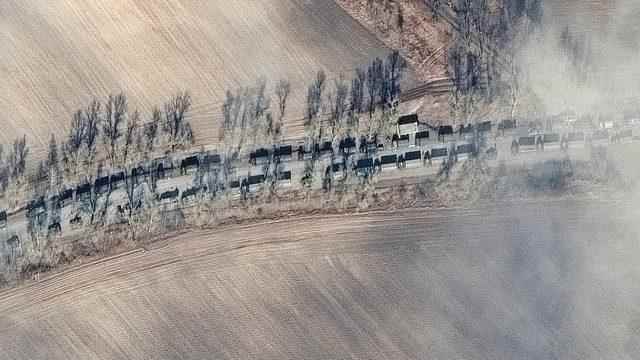
Photographs taken by orbiting satellites most recently captured images showing destroyed Russian helicopters, extensive damage to a shopping mall and residential areas in Mariupol, and a civilian tanker ship burning in the Black Sea.
Private companies that launch and operate their own satellites, such as Planet and Maxar, have distributed a large number of satellite images of the conflict zone.
Thanks to the sharing of these images, both the public and military analysts tried to measure the situation in Ukraine and the progress of Russia’s occupying armed forces from thousands of kilometers away.
Glen says satellite images were available online during previous conflicts, including the war in Syria. But he says the footage that was available at that time was “a drop in the ocean” compared to the amount of footage received from Ukraine in about two weeks.
Government and intelligence agency satellites have long acquired images classified as classified, while commercial firms have been able to sell their own images. And now, this material has become readily available online.
There are numerous businesses and organizations that use satellite imagery to monitor just about everything from wildfires to the condition of crops to the movement of ships. Chris Quilty, partner at Quilty Analytics research company, which focuses on the Satellite and Space industries, says the massive increase in the number of commercial satellites in orbit has significantly increased data sharing possibilities:
“There are more eyes in the sky.”
Users can purchase high-quality images collected by satellites for up to $10 per square kilometer.
The resolution of these images can be high enough to capture tiny details in an area of 30 square centimeters at ground level. This level of detail makes it possible to identify vehicles and road signs.
Operators can also program satellites to scan specific locations multiple times in 24 hours, capturing even small changes almost as soon as they happen.
WHAT HAS CHANGED IN LAST YEARS?
As technology progressed, the public’s interest in satellite images increased.
“The satellites’ ability to take images hasn’t changed much, but the way and willingness of users to capture and use that data has changed,” says Chris Quilty.
Thanks to technological innovations, more complex and Synthetic Aperture Radar (SAR) images can be taken. These images can be more difficult to interpret than a photograph taken with an optical lens.
Satellites can capture SAR images even after cloud cover. The resulting black and white images can show vehicles, including tanks, as bright rows of dots.
Glen says such footage has helped him and people like him watch the beginning of the invasion of Ukraine.
Rita Konaev, of the analysis department at Georgetown University’s Center for Security and Emerging Technology, said satellite imagery “has been an aspect of modern warfare technologies for 10 to 15 years, but the scale [bu sefer] and accessibility has changed,” he says, adding that “satellite imagery helps combat disinformation about invasions.”
Dr. “The architecture of European cities like Kyiv is very familiar to the Western world. This familiarity may have influenced the West’s response to the invasion, as opposed to wars in the Middle East and further afield,” says Konaev.
Glen says followers of Conflict News and similar social media accounts can verify satellite images by checking online sources:
“You can present the evidence to a wider audience as impartially as possible and let people come to their own conclusions.”
Some private companies are sharing complex images taken from orbit – in near real time – directly with the Ukrainian military. Canadian firm MDA is an example.
Dr Konaev says satellite images offer a unique perspective on events occurring thousands of kilometers away, which partly explains the surge in interest in these images.
But making such detailed images so widely available may have some important consequences.
Armies have a wide range of intelligence sources that they use outside of social media. However, it is not known how satellite images of troop movements shared on Twitter or Facebook could affect operational decisions in the field.
Dr. “It’s likely to influence life-or-death decisions,” says Konaev.
Glen is aware of this possibility, but will never know whether an image he shares will ultimately lead to a deadly attack or a battle on the front:
“I can’t say it made me hesitate, but I know it’s a possibility,” he says. “And I’ve come to terms with that.”