How about going back in time to see what your city or neighborhood once looked like? It’s possible thanks to this astonishing site which offers you images taken from the sky over the last few decades!
Like most people, you’ve probably already taken a trip to Google Maps or Google Earth to see your neighborhood, your city, your region, a famous place or even a vacation destination. And you have certainly taken advantage of satellite images to explore the surroundings of your home from another angle, perhaps discovering secrets invisible from the ground. This type of virtual walk is as informative as it is pleasant, and you can indulge in it for hours as there are so many details to examine, in France as everywhere on the planet.
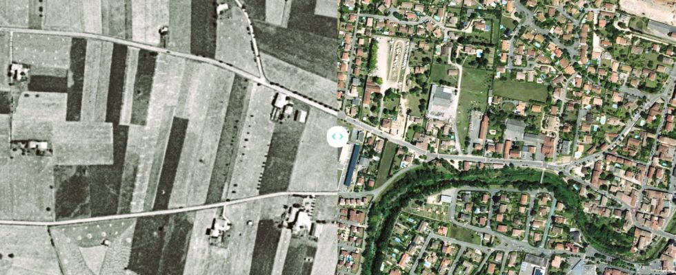
But as spectacular and practical as they are, these excellent Google services only offer fairly recent images, most of which are only a few years old. Perfect for seeing places as they are today, but not as they once were. However, it can be very interesting to see places as they once were, several decades ago. And, better yet, to compare them to what they have become. Especially if they have experienced big changes, as is generally the case in areas that have become urbanized.
This is precisely what allows Go back in time. Designed by the National Institute of Geographic and Forestry Information, better known by its acronym IGN, this completely free website allows you to display and compare aerial views of a place in France at different times, between today , 2006-2010, 2000-2005 and 1950-1965, based on a huge collection of photographs (around 4 million images).
Once on the site, simply define a location in the appropriate field (address, city, postal code, etc.) and select two periods to see the photos displayed side by side. Better yet, you can not only zoom in the image to examine details, but also drag the slider that separates the two views in the image to better compare the changes. A pane on the right also allows you to choose other layouts, with a vertical or horizontal separator or juxtaposed views. You can even activate a magnifying glass which displays in a circle an area at a time different from that of the overall photo.

Regardless of the display mode selected, the result is often spectacular! Particularly in areas which have undergone major changes. We thus see large agricultural lands disappearing to make way for buildings, with new roads, engineering structures and even railway lines. Some neighborhoods are completely transformed, filling with homes and commercial or craft zones. The site highlights some emblematic places, such as La Grande Motte, Notre-Dame or Chamonix, but you can walk anywhere in France to see how a district or a monument has evolved. And the zoom is powerful enough to clearly visualize houses and paths. Enough to measure, visually, the extent of urbanization work on the territory, and, more generally, human interventions on nature.
Certainly, unlike Google services, there is no function equivalent to Street View for virtually walking through streets and seeing changes in the ground. On the other hand, it is possible to download individual photos of areas taken in specific years, but also to display maps at different times. So many very informative views to virtually go back in time on an exciting walk. We might as well warn you, you may be surprised when you see what your place of residence or vacation looked like half a century ago…