France is bringing out the fans to get through a new heat wave, which could be the most intense of the year. A wave of extreme temperatures has set in since Wednesday August 16. Under the effect of a “heat dome”, two thirds of France (49 departments) are placed in orange vigilance this Sunday August 20 (they will be 50 on Monday), that is to say almost all departments under the line linking Bordeaux to Strasbourg.
This heatwave episode “promises to be the hottest of summer 2023, also as one of the latest with such a level of intensity for a summer season”, warns Météo France. This Sunday, even higher peaks than the day before were expected in the Toulouse Midi with 38 to 39 ° C, and up to 40 to 41 ° C in the lower Rhône valley, between Carpentras, Nîmes and Montélimar. The peak of intensity is expected early next week, Tuesday or Wednesday, with temperatures that could locally exceed 40 degrees. Warm nights, where the thermometer will not drop below 20 degrees, are expected in several southern regions.
The Mediterranean a dome
This episode is due to a heat dome which has been suffocating the Mediterranean rim for already more than a week. And particularly Spain, where the 44 degree mark has been regularly exceeded, especially in Andalusia. On August 10, Valencia broke its previous heat record with +3.4°C, ending the day at 46.8°C. Temperatures above 40 degrees are also expected in the coming days, especially in the east of the peninsula and in the Balearic Islands.
Another country that broke a heat record: Turkey. For the first time in recorded history, the 50°C mark was seen in Hassa, while many other cities were sweltering below 45 degrees.
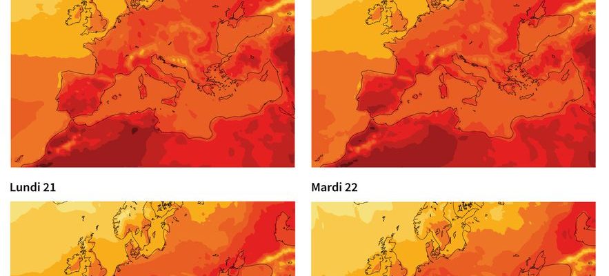
Map of Europe and the Mediterranean rim showing the evolution of temperatures from August 19 to 22, 2023, according to ECMWF forecasts up to August 18.
© / AFP
These suffocating conditions are created by a vast static anticyclone coming from Africa, that is to say masses of hot air coming from the Sahara through Algeria and Morocco. A heat dome was then set up around the Mediterranean. The operation is the same as that of a lid on a saucepan: the hot air is trapped under a screed, which heats it by compression over the days.
The phenomenon is moving towards central Europe
Italy is currently experiencing its third heat wave. In the coming days, the most affected areas will be the plains of northern Italy and the coast of the Tyrrhenian Sea, where the mercury will reach 40°C, as well as Sardinia (42°C). The cities of Florence, Rome, Bologna and Terni are on alert because of this situation which could last until August 27, according to the national meteorological agency. A stormy barrier will then be expected in Europe. The Alpine region is expected to experience temperatures between 9 and 12 degrees above average.
This phenomenon is gradually spreading to central Europe. Switzerland should also be affected by this heatwave episode over the next few days, with 37 degrees expected. On Friday, authorities issued a level 3 (out of 5) heat warning for almost all of the country below 600 meters above sea level. In Germany, red alerts for heat warnings have been issued in Berlin, where the mercury has already soared to 32C over the weekend – 30C in Frankfurt and Hamburg. England is also already experiencing a heat spike, and is expected to record above normal temperatures of 6 to 8 degrees next Wednesday.
Recently, the World Meteorological Organization (WMO) recalled in its 2022 report on the state of the climate in Europe that the continent “has warmed up twice as much as the world average” since the 1980s. In 2022, the average European temperature has was about 2.3°C higher than the pre-industrial average (1850-1900), taken as a reference in the Paris Agreement.