You will also be interested
[EN VIDÉO] The fascinating world of clouds Look at the clouds passing: it comes in all shapes. Here we show you some of them, which reside on different “floors”, as meteorologists say.
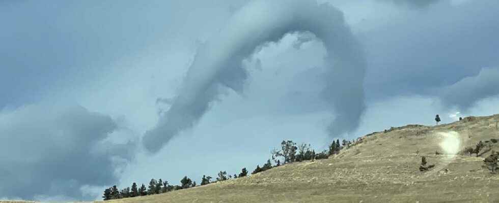
If finding a iron on horseback is considered a symbol of luck, seeing a cloud in the shape of a horseshoe requires even more luck as this phenomenon is rare and ephemeral. The horseshoe-shaped cloud (horseshoe vortex clouds, in English) takes on the appearance of an inverted U. It has already been observed all over the world, at any season. It generally forms in calm or slightly unstable weather (cloudy periods or light showers) and its duration life varies from a few seconds to a few minutes.
One of the rare clouds ever. This was taken over Battle Mountain, Nevada, USA on March 8, 2018.
It’s called a horseshoe cloud for obvious reasons. #nvwx
Credit goes to eagle-eye Christy Grimes. pic.twitter.com/XgQDY77ZzM
— NWS Elko (@NWSElko) March 9, 2018
A cloud created by the meeting of different winds
The horseshoe-shaped cloud is actually a cumulus which deforms. The cumulus are fine weather clouds, present at an altitude of 2 to 3 km. When conditions are unstable, cumulus clouds may rise and become cumulus congestus, shower clouds and eventually cumulonimbus, storm clouds. The formation of the horseshoe cloud requires a current ofair ascending, often in connection with an area heated by the rays of the sun : this hot air rises while swirling (thus creating a vortex) in its rise when it encounters a powerful crosswind.
A horizontal tube is then formed, inside which the pressure fall. The tube, or cloud ribbon, ends up deforming and partly falling back, before completely dislocating and disappearing. The middle of the vortex concentrates the fastest winds, hence its horizontal shape, and the two ends, with slower winds, fall back. The larger the cumulus present before the formation of the vortex, the longer the tube will resist, conversely: it will dissipate very quickly if the cumulus was thin.
A horseshoe-shaped cloud and its deformation, in Patagonia, in 2011. © Alfredo Ristol
The phenomenon would almost look like a tornado, or rather a snorkel (the beginning of a tornado that does not touch the ground): it is indeed very similar, except that there is no storm cloud in the above at the origin of the formation of the phenomenon, unlike tornadoes and snorkels. The horseshoe-shaped cloud is actually closer to the Dust Devilsthe whirlwinds of dust which is created in the desert regions from an ascending current of warm air as well. In the same way as the Dust Devilshorseshoe-shaped clouds most often form in the afternoon, when the sun has warmed the lower layers of the atmosphere well.
An impressive triple horseshoe vortex in France
Among the most impressive horseshoe-shaped clouds observed in recent years, we find first of all the one photographed in Montanain Livingston (United States), in November 2021:
Even more astonishing, an incredible triple horseshoe vortex was photographed by multiple witnesses in the south-west of France, in the vicinity of Pau, also in November 2021. While many believed it to be a photo montage, both the apparition seemed unreal, the phenomenon was confirmed by photos of other witnesses taken at other stages of the formation of the phenomenon:
Support an editorial team committed to popularizing science on Patreon!
Our mission ? Return the knowledge accessible to everyone.
We produce our own articles, investigations and reports every day, all on a human scale. Support us in this approach and this ambition.
Subscribe to Futura on Patreon!
Two subscription plans are offered to you with the following advantages:
- ” Futura ad-free »: get guaranteed ad-free access to the entire site for €3.29/month (+VAT).
- ” I participate in the life of Futura »: in addition to access without advertising, take part in the life of our independent media (votes, new content, surveys, etc.) for €6.29/month (+VAT).
Interested in what you just read?
