You will also be interested
[EN VIDÉO] 5 clouds to recognize to predict the weather For millennia, humans have learned to predict the weather through cues from nature. Among them, clouds can give a good idea of the short-term weather.
Mountain peaks often appear “capped” by a cloud, all over the world and at any season. In the reliefs, the winds are channeled by the mountains and are forced to make their way. When’air is pushed by the wind, or heated by the sun, it rises along the mountain walls, and cools as it climbs. This mild valley air loses an average of 0.6°C every 100 meters.
Mountains create their own microclimate
You should know that hot air is more humid than cold air, and as it rises, the water vapor condenses and forms droplets, or ice crystals at altitude: this is the formation of orographic cloud. This can be stable (fog, for example) or unstable (a cumulonimbus cloud,thunderstorm and showers).
Some classic Levante cloud action over the Rock of #Gibraltar this morning.
When moist easterly winds (Levante) hit the Rock, the air is forced to rise and cool rapidly, forming this area of cloud. pic.twitter.com/WOcTSWKyn7— Met Office Gibraltar (@MetOGibraltar) April 29, 2022
The formation of clouds above the mountains thus depends on two parameters: relief and wind. The clouds therefore do not cling to the mountains, they in fact very often form directly above them, or just upstream, due to the winds, which explains why the rest of the sky is clearer. The mountains actually create their own microclimate with, sometimes, variations weather report extremes between the summit and the valleys below.
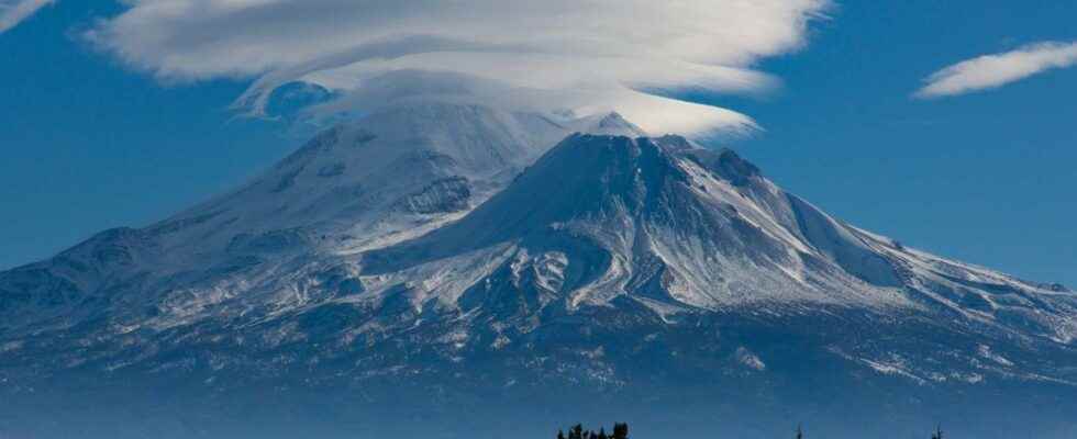
The special case of “hood” clouds
Other types of clouds are sometimes clinging to mountain peaks. These are wave clouds: among the most spectacular are the lenticular which can take the form of a cap (Cape cloud in English) covering a mountain peak. The most famous of the lenticulars crowning a mountain is that of the Mount Fuji in Japan, the kasagumo in Japanese.
Among the other lenticulars in the form of a cap, we also find that of the Mount Kilimanjaro in Tanzania.
In the United States, the most spectacular is undoubtedly that of the Mount Rainiernear Seattle, Washington.
In France, the Mont-Blanc often appears with a “cap”, a simple altocumulusand sometimes with what is called in Haute-Savoie “the donkey of Mont-Blanc”, a small lenticular cloud.
Wave clouds are also orographic clouds which are therefore formed thanks to the action of the wind perpendicular to the reliefs, but downstream. The wind that circulates above the summits shapes the lenticulars, which gives a static cloud but whose shape, reminiscent of a flying saucer or a plate, is always in movement. This type of cloud is shaped like pottery by the flowing currents. Wave clouds, like lenticulars, do not, however, give any precipitation. They simply indicate that the currents at altitude are very powerful, even if there is often no wind on the plain, at the level of the person who observes them.
Interested in what you just read?