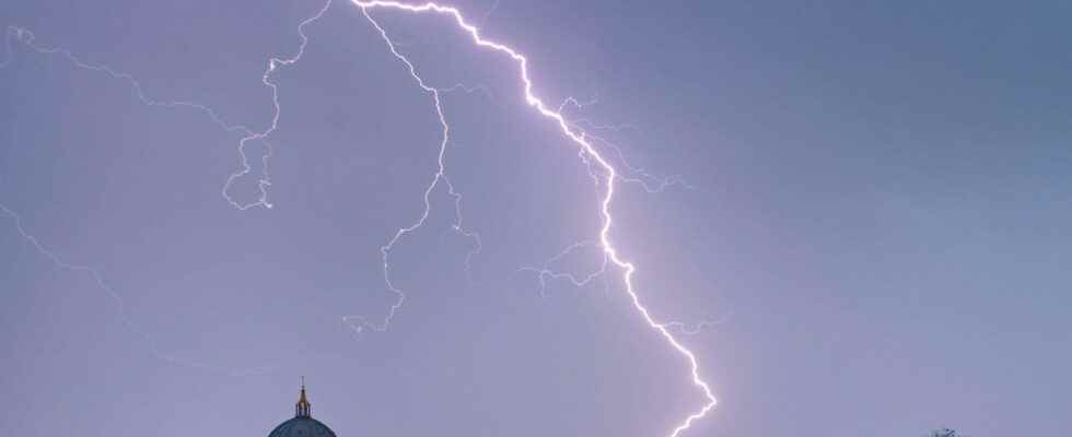
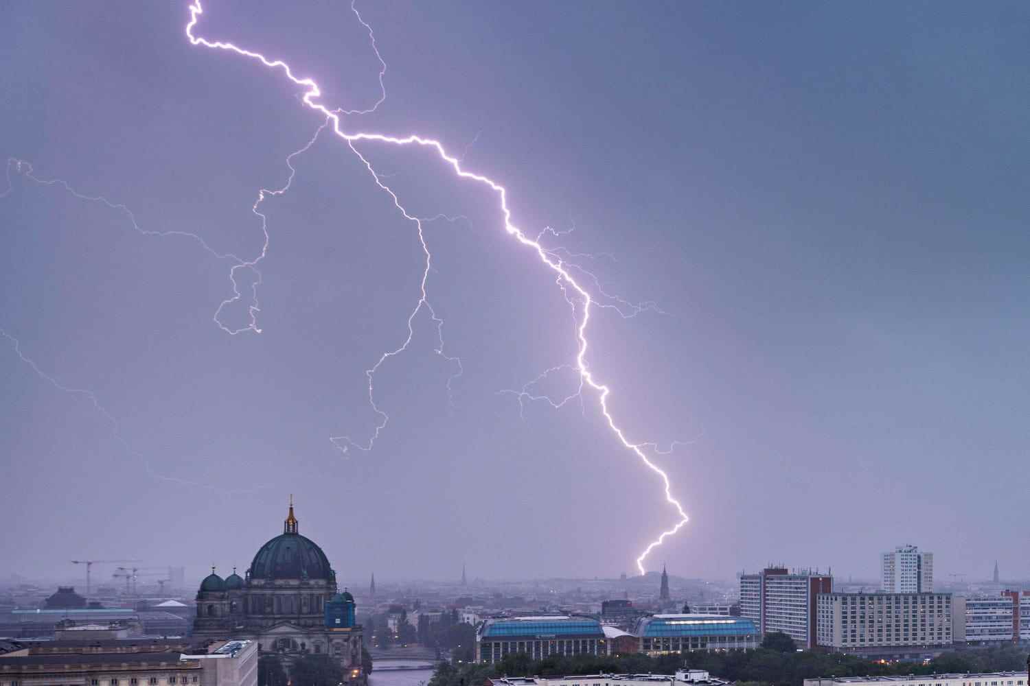
THUNDERSTORMS. Météo France has extended the list of departments placed on orange vigilance for thunderstorms this Wednesday, August 17, 2022. Thirteen departments in the south, east and north-west of the country are concerned and four of them run the risk of seeing floods form.
The essential
- Météo France placed thirteen departments on orange vigilance against thunderstorms this Wednesday August 17, 2022: Var, Bouches-du-Rhône, Vaucluse, Gard and Hérault were joined by Seine-Maritime, Calvados and Sleeve. In the middle of the afternoon, Ain, Isère, Pas-de-Calais, Rhône and Haute-Savoie were added to the list.
- Four of these departments are also concerned by orange vigilance in the face of the risk of flooding. The threat concerns exclusively the south-east of the country and only the department of Vaucluse is spared.
- Follow the latest weather forecast in this live.
Live
17:41 – In Saint-Etienne, thunderstorms compared to “hurricanes”
The stormy episode which hit Saint-Etienne was short but virulent. In the early afternoon, heavy rain fell on the region but also large hailstones. Faced with the deluge, a surfer quoted by ActuSaint-Etienne compared the scene to “a hurricane”. The streets of the city were flooded and plagued by mudslides and in the rain and wind trees were uprooted. Several damages are to report.
16:59 – Up to 60 mm of rain expected in the north
In Normandy and in the north of France, the meteorological institute predicts frequent and quite violent stormy rains. “They will be able to give locally up to 40 to 60mm in a very short time”, adds the forecasters.
4:43 p.m. – Storms and gusts at 130 km / h in the Rhône-Alpes
In Rhône-Alpes, where several departments have just been placed on orange vigilance in the face of thunderstorms, Météo France forecasts violent stormy episodes, some have already crossed Saint-Etienne and Lyon. It is above all the winds that blow in the region with gusts of up to 130 km / h and hail with hailstone falls of sometimes more than 3 cm that are worrying.
4:29 p.m. – Storms are rising over the Massif Central
The observations of La Chaîne Météo show that violent storms are rising in the Rhône valley and on the Massif Central with gusts of wind going to more than 100 km / h in places.
very violent #thunderstorms on the east of the Massif Central going up towards Saint-Etienne and in the Gier valley. In Saint-Chamond (42), a gust reached 131 km/h, the second strongest wind value ever recorded at the station. The temperature there fell from 26 to 15°C in 20 minutes pic.twitter.com/0F0Ry53qWO
— The Weather Channel (@lachainemeteo) August 17, 2022
16:13 – Storm orange vigilance extended to five new departments
At 4 p.m., Météo France announced the addition of five departments to the list of territories placed on orange vigilance in the face of thunderstorms, these are Ain, Isère, Pas-de-Calais, Rhône and of Haute-Savoie. In total, 13 departments are therefore on alert for bad weather this Wednesday, August 17.
16:09 – What are the good reflexes to have during thunderstorms? (3/3)
In the face of thunderstorms and floods, a simple way to limit the risks is to stay at home or at least limit travel as much as possible. Météo France recalls that 30 cm of water can be enough to carry a car with the current. Even with a lower water level, the risks are also significant if you have to move, think about reducing your speed considerably to avoid aquaplaning and extending the safety distances with other vehicles.
15:53 - What are the good reflexes to have during thunderstorms? (2/3)
Storms are often accompanied by risks of flooding too, it is necessary to keep informed about these risks with the authorities to know what behavior to adopt. It is necessary to know if you are in a flood zone and know the procedure to follow to take shelter if necessary. In general, high places such as floors are to be preferred, while on the contrary, parking lots and basements that are more easily flooded should be avoided.
15:37 – What are the good reflexes to have during thunderstorms? (1/3)
Storms, especially violent episodes such as those raging in the eight departments on orange alert this Wednesday, August 17, the risks are significant and several tips can limit them and take shelter. You must first take shelter from lightning, especially when there is a lot of electrical activity. Météo France reminds you to avoid swimming and get out of the water and not to go to the tops of mountains or hills. Lightning is attracted to electrical conductors or raised or high objects, so it is recommended to stay away from utility poles and trees. For shelter, it is necessary to prefer solid buildings.
15:21 – The Old Port of Marseille flooded due to storms
In Marseille it is the equivalent of one or even several months of rain that has fallen since last night and the start of the stormy episode. The torrential rains caused the flooding of the Old Port of the Marseille city, amateur videos in particular taken up by BFM TV showed the water dripping down the roads. The place was under them last night, overnight and again this morning but since the situation has returned to normal.
15:04 – The end of the orange vigilance expected in the evening
Météo France has published its first forecasts for tomorrow and all orange vigilance, storms and floods should be lifted. However, the weather will still be overcast and stormy in places, particularly on the eastern side of the country. The Rhône Valley and the Provence-Alpes-Côte d’Azur region could still be under stormy showers, but only occasionally.
14:47 – “Temporarily strong thunderstorms” in Normandy
In Normandy, where three departments are placed in orange vigilance, the weather specialist institute announces “temporarily strong storms” as well as large accumulations of rain. Stormy showers can also occur in Hauts-de-France classified in yellow vigilance. In the neighboring regions of Normandy, Brittany, Pays de la Loire and Ile-de-France only a few showers are expected and they should only very rarely be accompanied by thunderstorms.
14:33 – In the south, thunderstorms are heading east
Storms will continue to hit south-eastern France this afternoon and should move towards the east of the Provence-Alpes-Côte d’Azur region at the end of the day according to Météo France forecasts. However, by then the storms will be not very mobile and the water level could reach accumulations of 100 to 150 mm in places. The meteorological institute adds that in the areas of the Rhône valley, the Massif central and in the northeast “many stormy showers follow one another”.
14:19 – Authorities recommend limiting travel in the face of flood risk
Faced with thunderstorms and the risk of flooding, the authorities of the departments in orange vigilance invite the populations to reduce as much as possible and postpone their trips or failing to find out about the weather before hitting the road. The Var prefecture also insisted in a press release on the risks incurred, recalling that “30 cm of water is enough to carry a car”. The authorities add that it is strictly inadvisable to stay close to watercourses or to take shelter under a tree.
14:00 – The beaches of Marseille prohibited for swimming due to storms
If the torrential rains and thunderstorms have deterred most residents and holidaymakers from swimming on the beaches of Marseille, the municipality has officially banned swimming in a decree published on Wednesday. In addition to the danger, the backwater caused by the bad weather has affected the quality of the water, the City has indicated that analyzes will be carried out before the reopening of the beaches.
1:30 p.m. – The east and north-west of France on the alert in the face of thunderstorms

The Weather Channel does not place the whole of France on alert but considers that a large part of the departments in the east of the country and in the north-west are on alert, yellow for the most part and orange for seven departments in the south: Var, Bouches- du-Rhône, Vaucluse, Hérault, Gard, Ardèche and Drôme. Forecasts slightly different from those of Météo France but which confirm the trend: stormy episodes are concentrated in two geographical areas, the Mediterranean coast and that of the English Channel.
READ MORE
Learn more
They are thirteen departments to be placed in orange vigilance for thunderstorms this Wednesday August 17, 2022. After the addition of Seine-Maritime, Calvados and Manche to the list of departments on alert, it is the turn of the Ain, Isère, Pas-de-Calais, Rhône and Haute-Savoie to be placed on orange vigilance in the face of thunderstorms. The Var, Bouches-du-Rhône, Vaucluse, Gard and Hérault have been on the alert since yesterday. The stormy episode which took place overnight from Tuesday to Wednesday continues and has been concentrated in the southeast since the end of the morning in the northwest of the country. Intense precipitation, hailstorms and gusts of wind “of the order of 80 to 100 km / h” are expected according to forecasts from Météo France. The rain has already fallen in impressive quantities this morning on the Mediterranean rim as in Marseilles where the equivalent of less rain fell in a few hours. The Weather Channel estimates that “the accumulations of rain could reach 40 to 50 mm as thunderstorms pass with, in total, accumulations of up to 100 to 150 mm in the Cévennes taking into account the precipitation that has fallen since yesterday evening” but specifies that the thunderstorms will be “a priori more diffuse and more localized than initially feared”.
In Normandy, where three departments are concerned by the alert, several sequences of stormy showers are expected. The neighboring region of Hauts-de-France is also likely to see thunderstorm precipitation in the sky. In Brittany, in the Pays de la Loire and in Ile-de-France, some showers may occur but without reaching the same intensities. If only eight departments are placed in orange vigilance, the neighboring territories must remain cautious since according to La Chaîne Météo estimates that twelve other departments of Provence-Alpes-Côte d’Azur, Auvergne-Rhône-Alpes and Occitanie are at risk. to see violent storms breaking out. All of France is covered at least by clouds and several showers fall in all regions. The storms hit in particular the middle valley of the Rhône, the Massif central. While thunderclaps and hail are expected in the center-east and some showers circulate from Pays de la Loire to the Belgian border according to the forecast. The Southwest and the Paris basin could also see the rains intensify in the afternoon according to the weather forecast.
With such quantities of water, four departments in the south-east, Var, Bouches-du-Rhône, Gard and Hérault, are also placed under orange vigilance for the risk of flooding. The fault of the torrential rains which follow the episode of drought and run off without being able to penetrate the soil. It is sudden flooding of rivers and streams and the accumulation of rainwater in the city that are feared.
Images of violent storms abound and several amateur videos show the violence of the rains. In Marseille, this Wednesday, August 17, the Old Port was under water after a night of showers. In Montpellier also the storms and the rains are impressive while in Hyères near Toulon it is the size of the hailstones that challenge.